IMAGES TAKEN NEAR TO
Bryning Avenue, PRESTON, PR4 2WL
Introduction
This page details the photographs taken nearby to Bryning Avenue, PR4 2WL by members of the Geograph project.
The Geograph project started in 2005 with the aim of publishing, organising and preserving representative images for every square kilometre of Great Britain, Ireland and the Isle of Man.

There are currently over 7.5m images from over14,400 individuals and you can help contribute to the project by visiting https://www.geograph.org.uk
Image Map
Images are licensed for reuse under creativecommons.org/licenses/by-sa/2.0
Notes
- Clicking on the map will re-center to the selected point.
- The higher the marker number, the further away the image location is from the centre of the postcode.
Image Listing (5 Images Found)
Images are licensed for reuse under creativecommons.org/licenses/by-sa/2.0
Image
Details
Distance
1
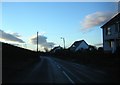
Bryning Lane,Wrea Green
Heading south, out of the village.
Image: © Peter Bond
Taken: 11 Jan 2011
0.11 miles
2
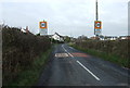
Entering Wrea Green
Heading north on Bryning Lane.
Image: © JThomas
Taken: 15 Nov 2014
0.13 miles
3
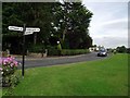
Fingerpost on the village green
At Wrea Green.
Image: © philandju
Taken: 1 Aug 2013
0.20 miles
4
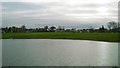
Wrea Green Cricket Club
Looking across the pond towards the square at Wrea Green CC.
Image: © BatAndBall
Taken: 18 Feb 2015
0.24 miles
5
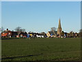
Football match on the village green
Lots of vocal encouragement and enthusiasm! (I did try to find out who was playing whom, but all the relevant footie websites seem to be discontinued.)
Image: © Barbara Carr
Taken: 10 Nov 2013
0.24 miles