IMAGES TAKEN NEAR TO
Foxwood Drive, PRESTON, PR4 2DS
Introduction
This page details the photographs taken nearby to Foxwood Drive, PR4 2DS by members of the Geograph project.
The Geograph project started in 2005 with the aim of publishing, organising and preserving representative images for every square kilometre of Great Britain, Ireland and the Isle of Man.

There are currently over 7.5m images from over14,400 individuals and you can help contribute to the project by visiting https://www.geograph.org.uk
Image Map
Images are licensed for reuse under creativecommons.org/licenses/by-sa/2.0
Notes
- Clicking on the map will re-center to the selected point.
- The higher the marker number, the further away the image location is from the centre of the postcode.
Image Listing (9 Images Found)
Images are licensed for reuse under creativecommons.org/licenses/by-sa/2.0
Image
Details
Distance
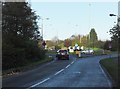
1
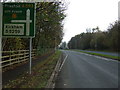
Blackpool Road
Heading south east towards Preston.
Image: © JThomas
Taken: 15 Nov 2014
0.14 miles
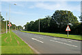
2
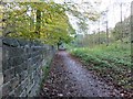
Footpath/cycleway to Wrea Green
On the southern side of the A582, west of Kirkham.
Image: © Barbara Carr
Taken: 10 Nov 2013
0.19 miles
3
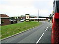
St.George's Business Park
This is just outside Kirkham on the A585 link road from the M55 motorway.
Image: © Roger May
Taken: 15 Aug 2005
0.19 miles
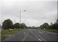
5
The B5259, approaching roundabout on the A582
Image: © Barbara Carr
Taken: 10 Nov 2013
0.20 miles

9
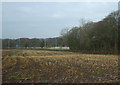
Stubble field near Stable Wood
Towards the A583.
Image: © JThomas
Taken: 15 Nov 2014
0.24 miles