IMAGES TAKEN NEAR TO
Gilbert Way, PRESTON, PR4 1FE
Introduction
This page details the photographs taken nearby to Gilbert Way, PR4 1FE by members of the Geograph project.
The Geograph project started in 2005 with the aim of publishing, organising and preserving representative images for every square kilometre of Great Britain, Ireland and the Isle of Man.

There are currently over 7.5m images from over14,400 individuals and you can help contribute to the project by visiting https://www.geograph.org.uk
Image Map
Images are licensed for reuse under creativecommons.org/licenses/by-sa/2.0
Notes
- Clicking on the map will re-center to the selected point.
- The higher the marker number, the further away the image location is from the centre of the postcode.
Image Listing (29 Images Found)
Images are licensed for reuse under creativecommons.org/licenses/by-sa/2.0
Image
Details
Distance
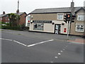
2
Derelict Fruit & Vegetable Shop and Keep Out Sign, Lytham Road, Warton
The shop originally had a semi-circular drive in front of it ... just about still visible in this picture
For more information about this site ... see ...
Image
Image
Image
Image
Image: © Terry Robinson
Taken: 9 Feb 2013
0.17 miles
4
Derelict Fruit & Vegetable Shop, Lytham Road, Warton
Image: © Terry Robinson
Taken: 8 Feb 2013
0.18 miles
5
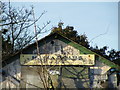
Derelict Fruit & Vegetable Shop Sign, Lytham Road, Warton
What does it read? Haigh's ... possibly.
For more information about this building ... see ...
Image
Image
See also ...
Image
Image: © Terry Robinson
Taken: 8 Feb 2013
0.18 miles
6
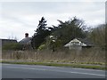
Derelict Bungalow and Fruit & Vegetable Stall, Lytham Road, Warton - 2
For more information about these buildings and the site ... see ...
Image
See also ...
Image
Image
Image
Image: © Terry Robinson
Taken: 1 Mar 2013
0.18 miles
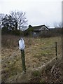
7

Keep Out Sign, Lytham Road, Warton
For an explanation ... see ...
Image
Image: © Terry Robinson
Taken: 9 Feb 2013
0.18 miles
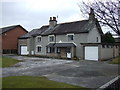
8
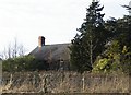
Derelict Bungalow and Fruit & Vegetable Shop, Lytham Road, Warton - 1
I used to live in Warton and in the late 1960s / early 1970s walked to the Fruit & Vegetable Shop on most Saturdays ... not just to buy Fruit & Vegetables for my Mum and Dad ... but also to see and chat to the Girl who worked there. I moved away a few years later ... I wonder what did happen to her.
I believe the Bungalow, Shop and adjoining field, in the picture, were compulsorily purchased in the mid 1970s with the intention being to build a junction for a proposed Warton By-Pass and the A584 Lytham Road. The Warton By-Pass was supposed to be an extension of the Freckleton By-Pass - Freckleton being the neighbouring village nearer to Preston. Freckleton did get its By-Pass in (I believe) 1986 and the proposed Warton By-Pass would have been built as a road off the small roundabout where the existing dual carriageway ends. The By-Pass would then have followed a line around and behind Warton Village and eventually would join the A584 where these buildings now still, just about, stand.
Methinks the Warton By-Pass will never be built.
The shown plot of land is now owned by the National Estates Council who inform me that they are planning to build houses on it.
See also ...
Image
Image
Image
Image
Image
Image
Image: © Terry Robinson
Taken: 1 Mar 2013
0.18 miles
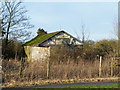
9
Derelict Bungalow, Lytham Road, Warton
Image: © Terry Robinson
Taken: 8 Feb 2013
0.18 miles
10
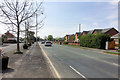
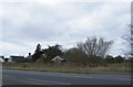
A584, Lytham Road, Warton
At the western end of the Freckleton Bypass, the A584 passes through the village of Warton and continues as an urban road with a 30 mph speed limit for some distance.
Image: © David Dixon
Taken: 22 Apr 2019
0.19 miles