IMAGES TAKEN NEAR TO
Millfield Close, PRESTON, PR4 1EB
Introduction
This page details the photographs taken nearby to Millfield Close, PR4 1EB by members of the Geograph project.
The Geograph project started in 2005 with the aim of publishing, organising and preserving representative images for every square kilometre of Great Britain, Ireland and the Isle of Man.

There are currently over 7.5m images from over14,400 individuals and you can help contribute to the project by visiting https://www.geograph.org.uk
Image Map
Images are licensed for reuse under creativecommons.org/licenses/by-sa/2.0
Notes
- Clicking on the map will re-center to the selected point.
- The higher the marker number, the further away the image location is from the centre of the postcode.
Image Listing (30 Images Found)
Images are licensed for reuse under creativecommons.org/licenses/by-sa/2.0
Image
Details
Distance
4
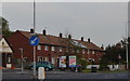
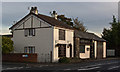
Former RAF Houses, Lytham Road, Warton, near Preston
Warton Airfield - now the BAe Systems site - was originally constructed as an RAF Warton which served as a 'satellite' airfield for the RAF Coastal Command based at Squires Gate***, near Blackpool.
This row of houses and an estate of similar housing situated on land behind these, were constructed as housing for the 'rank and file' RAF personnel based at the site**
They are now owned by the local Council or have been purchased and are owned privately.
** The Officers and NCO's were based at another nearby location ... see ...
Image
*** Now the site of Blackpool's Squires Gate Airport
See also ...
Image
Image
Image: © Terry Robinson
Taken: 1 Oct 2013
0.14 miles
5
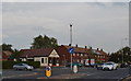
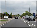
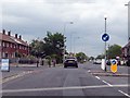
Harbour Lane and Lytham Road Junction, Warton, near Preston
Image: © Terry Robinson
Taken: 1 Oct 2013
0.16 miles
6
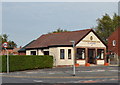
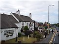
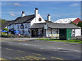
Marsdens Funeral Home, Lytham Road, Warton
Back in the 1960s ... and for many years afterwards ... I remember this building as the local Paper Shop.
I also remember the word CAFE being (just) visible on the roof ... probably dating from when the 1940s when the Americans took over Warton Airfield, which is situated over the road from this building (and behind the photograph position).
The Americans developed the Airfield into the BAD2 Airbase. I believe BAD1 was in Warrington.
The Airfield is now owned by BAe Systems as their Warton facility.
The McColl shop just down the road now serves the village and BAe workers with their Newspapers and
Magazines.
See also ...
Image
Image
Image
Image
Image
Image
Image
Image
Image
Image
Image: © Terry Robinson
Taken: 1 Oct 2013
0.18 miles
9
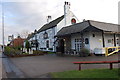
Pickwick Tavern, Warton
The Pickwick tavern on the A584 (Lytham Road) in Warton.
Image: © David Dixon
Taken: 22 Aug 2011
0.20 miles