IMAGES TAKEN NEAR TO
Fir Grove, PRESTON, PR4 1DA
Introduction
This page details the photographs taken nearby to Fir Grove, PR4 1DA by members of the Geograph project.
The Geograph project started in 2005 with the aim of publishing, organising and preserving representative images for every square kilometre of Great Britain, Ireland and the Isle of Man.

There are currently over 7.5m images from over14,400 individuals and you can help contribute to the project by visiting https://www.geograph.org.uk
Image Map
Images are licensed for reuse under creativecommons.org/licenses/by-sa/2.0
Notes
- Clicking on the map will re-center to the selected point.
- The higher the marker number, the further away the image location is from the centre of the postcode.
Image Listing (4 Images Found)
Images are licensed for reuse under creativecommons.org/licenses/by-sa/2.0
Image
Details
Distance
1
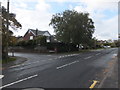
Church Road, Warton
At the junction with Marlborough Avenue.
Image: © Barbara Carr
Taken: 23 Oct 2013
0.14 miles
2
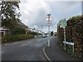
Sunnyside Avenue, Warton
Residential area in the northern part of Warton.
Image: © Barbara Carr
Taken: 23 Oct 2013
0.20 miles
3
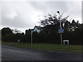
At the western end of Hillock Lane
The road southeasterly to Warton is known as Church Road, and northwesterly into Kellamergh it's called Bryining Lane.
Image: © Barbara Carr
Taken: 23 Oct 2013
0.21 miles
4
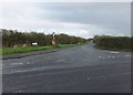
Hillock Lane
Looking northwesterly from the junction with the road from Warton.
Image: © Barbara Carr
Taken: 23 Oct 2013
0.22 miles