IMAGES TAKEN NEAR TO
PR4 0YW
Introduction
This page details the photographs taken nearby to PR4 0YW by members of the Geograph project.
The Geograph project started in 2005 with the aim of publishing, organising and preserving representative images for every square kilometre of Great Britain, Ireland and the Isle of Man.

There are currently over 7.5m images from over14,400 individuals and you can help contribute to the project by visiting https://www.geograph.org.uk
Image Map
Images are licensed for reuse under creativecommons.org/licenses/by-sa/2.0
Notes
- Clicking on the map will re-center to the selected point.
- The higher the marker number, the further away the image location is from the centre of the postcode.
Image Listing (10 Images Found)
Images are licensed for reuse under creativecommons.org/licenses/by-sa/2.0
Image
Details
Distance
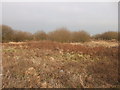
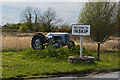
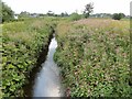
3
Dyke from footbridge, Carr House Green Common
Image: © Peter Bond
Taken: 19 Jul 2009
0.15 miles
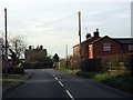
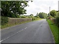
5
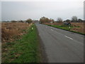
Preston Road. (B5269)
Heading south east, Carr House Green Common.
Image: © JThomas
Taken: 29 Nov 2014
0.17 miles
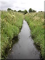
7
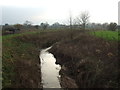
Woodplumpton Brook
Looking south from Woodsfold Bridge.
Image: © JThomas
Taken: 29 Nov 2014
0.22 miles
8
Woodplumpton Brook
From Woodsfold Bridge.
Image: © philandju
Taken: 22 Aug 2013
0.23 miles
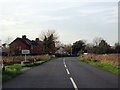
9
The B5260 at Woodsfold Bridge
The road from Inskip to Broughton.
Image: © philandju
Taken: 22 Aug 2013
0.23 miles