IMAGES TAKEN NEAR TO
Deepdale Lane, PRESTON, PR4 0RQ
Introduction
This page details the photographs taken nearby to Deepdale Lane, PR4 0RQ by members of the Geograph project.
The Geograph project started in 2005 with the aim of publishing, organising and preserving representative images for every square kilometre of Great Britain, Ireland and the Isle of Man.

There are currently over 7.5m images from over14,400 individuals and you can help contribute to the project by visiting https://www.geograph.org.uk
Image Map
Images are licensed for reuse under creativecommons.org/licenses/by-sa/2.0
Notes
- Clicking on the map will re-center to the selected point.
- The higher the marker number, the further away the image location is from the centre of the postcode.
Image Listing (10 Images Found)
Images are licensed for reuse under creativecommons.org/licenses/by-sa/2.0
Image
Details
Distance
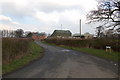
1
Sheep field in front of Pear Tree Farm
The farm is on the edge of Lea Town, but you wouldn't guess that is a neighbour of a nuclear fuel manufacturing plant.
Image: © Bill Boaden
Taken: 18 Apr 2012
0.02 miles

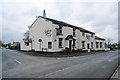
4
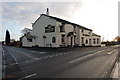
Smiths Arms
Local nickname The Slip Inn.
Image: © Keith Wright
Taken: 19 Dec 2005
0.15 miles
5
Smiths Arms, Lea Town
It was closed as I went past, but as it is a Thwaites pub, I wasn't too upset.
Image: © Bill Boaden
Taken: 18 Apr 2012
0.15 miles
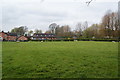
6

St Mary's RC Primary School, Lea Town
Traditional village school.
Image: © Bill Boaden
Taken: 18 Apr 2012
0.16 miles
7
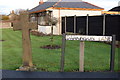
The cross on Darkinson Lane
The cross is next to Springfields atomic processing plant and The Smiths Arms.
Image: © Keith Wright
Taken: 19 Dec 2005
0.18 miles
8
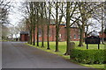
St Mary's RC Church, Lea Town
This is a strongly Catholic area with little competition from other churches.
Image: © Bill Boaden
Taken: 18 Apr 2012
0.21 miles
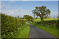
9
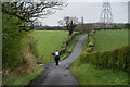
Horse-riding between Lea Town and Clifton
The lanes are generally quiet and are not dominated by traffic.
Image: © Bill Boaden
Taken: 18 Apr 2012
0.21 miles