IMAGES TAKEN NEAR TO
Darkinson Lane, PRESTON, PR4 0RE
Introduction
This page details the photographs taken nearby to Darkinson Lane, PR4 0RE by members of the Geograph project.
The Geograph project started in 2005 with the aim of publishing, organising and preserving representative images for every square kilometre of Great Britain, Ireland and the Isle of Man.

There are currently over 7.5m images from over14,400 individuals and you can help contribute to the project by visiting https://www.geograph.org.uk
Image Map
Images are licensed for reuse under creativecommons.org/licenses/by-sa/2.0
Notes
- Clicking on the map will re-center to the selected point.
- The higher the marker number, the further away the image location is from the centre of the postcode.
Image Listing (11 Images Found)
Images are licensed for reuse under creativecommons.org/licenses/by-sa/2.0
Image
Details
Distance

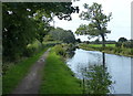
3
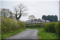
Darkinson Lane
Country lane with substantial hedges though they are trimmed. Halsall's Farm is visible ahead.
Image: © Bill Boaden
Taken: 18 Apr 2012
0.21 miles
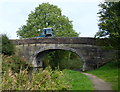
4
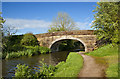
Bridge no. 19 on the Lancaster Canal
This picture is part of a series. Next is at Image
Image: © Patrick
Taken: 14 Oct 2007
0.21 miles
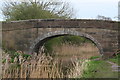
5
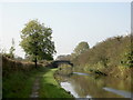
Quaker's Bridge No 19
Carrying Sidgreaves Lane across the Lancaster Canal at Cottam.
Image: © Mat Fascione
Taken: 16 Sep 2018
0.22 miles
7
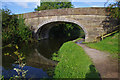
Bridge 19, Lancaster Canal
Quaker's Bridge - looking "south"
Image: © Ian Taylor
Taken: 26 Aug 2012
0.22 miles
9
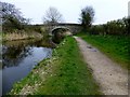
Quaker's Bridge
Quaker's Bridge is Bridge 19 on the Lancaster Canal.
Image: © Rude Health
Taken: 30 Mar 2014
0.23 miles