IMAGES TAKEN NEAR TO
Keats Way, PRESTON, PR4 0NL
Introduction
This page details the photographs taken nearby to Keats Way, PR4 0NL by members of the Geograph project.
The Geograph project started in 2005 with the aim of publishing, organising and preserving representative images for every square kilometre of Great Britain, Ireland and the Isle of Man.

There are currently over 7.5m images from over14,400 individuals and you can help contribute to the project by visiting https://www.geograph.org.uk
Image Map
Images are licensed for reuse under creativecommons.org/licenses/by-sa/2.0
Notes
- Clicking on the map will re-center to the selected point.
- The higher the marker number, the further away the image location is from the centre of the postcode.
Image Listing (5 Images Found)
Images are licensed for reuse under creativecommons.org/licenses/by-sa/2.0
Image
Details
Distance
1
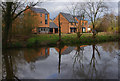
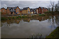
Greenfinch Avenue, Cottam Meadow
New housing development. Lancaster Canal in foreground.
Image: © Ian Taylor
Taken: 6 Mar 2019
0.18 miles
2
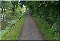
Towpath along the Lancaster Canal
On the right is a milepost, Garstang 14 miles, Preston 3 miles.
Image: © Mat Fascione
Taken: 16 Sep 2018
0.20 miles
4
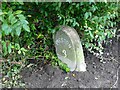
Old Milestone Marker 54-03 F (between bridges 18-17), Lancaster Canal
Old Milestone located by the side of the Lancaster Canal
This milestone is 3 miles from the centre of Preston and 54 miles from Kendal
Inscription reads:-
Preston / 3 :: Garstang / 14
Milestone Society National ID: LAN-03
Image: © Cactus Chris
Taken: 20 Dec 2021
0.21 miles
5
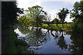
Copper Beech Lane, Cottam
New housing development. Lancaster Canal in foreground.
Image: © Ian Taylor
Taken: 6 Mar 2019
0.22 miles