IMAGES TAKEN NEAR TO
Dunlin Drive, PR4 0JX
Introduction
This page details the photographs taken nearby to Dunlin Drive, PR4 0JX by members of the Geograph project.
The Geograph project started in 2005 with the aim of publishing, organising and preserving representative images for every square kilometre of Great Britain, Ireland and the Isle of Man.

There are currently over 7.5m images from over14,400 individuals and you can help contribute to the project by visiting https://www.geograph.org.uk
Image Map
Images are licensed for reuse under creativecommons.org/licenses/by-sa/2.0
Notes
- Clicking on the map will re-center to the selected point.
- The higher the marker number, the further away the image location is from the centre of the postcode.
Image Listing (12 Images Found)
Images are licensed for reuse under creativecommons.org/licenses/by-sa/2.0
Image
Details
Distance
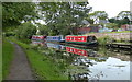
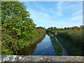
2
Lancaster Canal, Cottam
New house with moored narrow boats.
Image: © Ian Taylor
Taken: 6 Mar 2019
0.19 miles
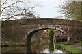
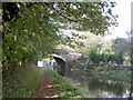
3
Bridge 18, Lancaster Canal
Looking "south"
Image: © Ian Taylor
Taken: 26 Aug 2012
0.20 miles
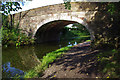
5
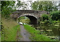
Lea Malt Kiln Bridge No 18
Carrying Lea Road across the Lancaster Canal at Cottam.
Image: © Mat Fascione
Taken: 16 Sep 2018
0.20 miles
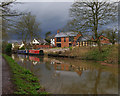
6
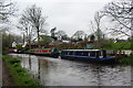
Narrowboats moored on the Lancaster Canal
Bridge 18 is just around the corner to the left.
Image: © Bill Boaden
Taken: 18 Apr 2012
0.20 miles
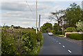
7
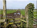
Muddy Footpath
A muddy footpath worsened by tractor tracks made when filling the ring feeder for the cattle.
Image: © Rude Health
Taken: 30 Mar 2014
0.21 miles
9
Bridge no. 18 on the Lancaster Canal
This picture is part of a series. Next is at Image
Image: © Patrick
Taken: 14 Oct 2007
0.21 miles
10
Lancaster Canal from Quaker's Bridge
Image: © Alexander P Kapp
Taken: 7 Oct 2012
0.23 miles