IMAGES TAKEN NEAR TO
Honey Road, PR4 0GF
Introduction
This page details the photographs taken nearby to Honey Road, PR4 0GF by members of the Geograph project.
The Geograph project started in 2005 with the aim of publishing, organising and preserving representative images for every square kilometre of Great Britain, Ireland and the Isle of Man.

There are currently over 7.5m images from over14,400 individuals and you can help contribute to the project by visiting https://www.geograph.org.uk
Image Map
Images are licensed for reuse under creativecommons.org/licenses/by-sa/2.0
Notes
- Clicking on the map will re-center to the selected point.
- The higher the marker number, the further away the image location is from the centre of the postcode.
Image Listing (6 Images Found)
Images are licensed for reuse under creativecommons.org/licenses/by-sa/2.0
Image
Details
Distance
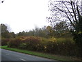
1
A forgotten pavement?
It looks like they built the pavement but forgot the road. Or maybe the protests from the residents in the houses behind the camera got the road stopped.
Image: © Ian Greig
Taken: 9 May 2014
0.09 miles
3
Preston Grasshoppers Rugby Union Football Club
Image: © Keith Wright
Taken: 30 Dec 2005
0.17 miles
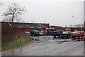
6
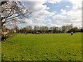
Preston Grasshoppers Rugby Union Football Club
The view from Sandyforth Lane across to Preston Grasshoppers Rugby Union Football Club's playing field. Sandyforth Lane is used as part of the Preston Guild Wheel cycle route.
Image: © Rude Health
Taken: 20 Apr 2013
0.24 miles