IMAGES TAKEN NEAR TO
Barnview Court, PRESTON, PR4 0FX
Introduction
This page details the photographs taken nearby to Barnview Court, PR4 0FX by members of the Geograph project.
The Geograph project started in 2005 with the aim of publishing, organising and preserving representative images for every square kilometre of Great Britain, Ireland and the Isle of Man.

There are currently over 7.5m images from over14,400 individuals and you can help contribute to the project by visiting https://www.geograph.org.uk
Image Map
Images are licensed for reuse under creativecommons.org/licenses/by-sa/2.0
Notes
- Clicking on the map will re-center to the selected point.
- The higher the marker number, the further away the image location is from the centre of the postcode.
Image Listing (8 Images Found)
Images are licensed for reuse under creativecommons.org/licenses/by-sa/2.0
Image
Details
Distance
3
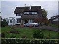
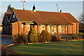
Club house, Woodplumpton and District Bowling Club
Image: © JThomas
Taken: 1 Nov 2014
0.14 miles
4
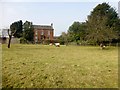
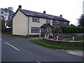
Sheep At Pasture
Sheep at pasture in front of house near Lower Bartle. Opposite this field there is an artificial tennis court next too the Woodplumpton Bowling Club.
Image: © Rude Health
Taken: 29 Mar 2014
0.17 miles