IMAGES TAKEN NEAR TO
Ash Tree Close, PRESTON, PR4 0ES
Introduction
This page details the photographs taken nearby to Ash Tree Close, PR4 0ES by members of the Geograph project.
The Geograph project started in 2005 with the aim of publishing, organising and preserving representative images for every square kilometre of Great Britain, Ireland and the Isle of Man.

There are currently over 7.5m images from over14,400 individuals and you can help contribute to the project by visiting https://www.geograph.org.uk
Image Map
Images are licensed for reuse under creativecommons.org/licenses/by-sa/2.0
Notes
- Clicking on the map will re-center to the selected point.
- The higher the marker number, the further away the image location is from the centre of the postcode.
Image Listing (17 Images Found)
Images are licensed for reuse under creativecommons.org/licenses/by-sa/2.0
Image
Details
Distance
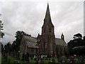
1
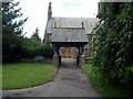
Lychgate at St. Peter's, Inskip
C. of E. parish church.
Image: © philandju
Taken: 6 Aug 2013
0.07 miles
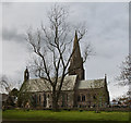
4
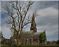
St. Peter's church , Inskip
St. Peter's church, Inskip
Image: © Galatas
Taken: 13 May 2009
0.10 miles
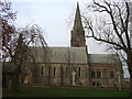
5
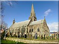
St Peter Church Of England, Inskip
This church was founded in 1848. The foundation stone of a church dedicated to St. Peter, was laid 10th June, 1847. Other places in the parish include: Sowerby. Inskip is a small village in the Fylde area of Lancashire, England. It is part of the civil parish of Inskip-with-Sowerby.
Image: © Rude Health
Taken: 3 Mar 2014
0.10 miles
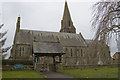
6
St. Peter's church, Inskip
C. of E. parish church.
Image: © philandju
Taken: 6 Aug 2013
0.10 miles
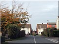
9
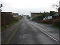
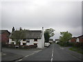
Preston Road, Inskip (B5269)
Heading south.
Image: © JThomas
Taken: 29 Nov 2014
0.12 miles