IMAGES TAKEN NEAR TO
PRESTON, PR3 9DN
Introduction
This page details the photographs taken nearby to PR3 9DN by members of the Geograph project.
The Geograph project started in 2005 with the aim of publishing, organising and preserving representative images for every square kilometre of Great Britain, Ireland and the Isle of Man.

There are currently over 7.5m images from over14,400 individuals and you can help contribute to the project by visiting https://www.geograph.org.uk
Image Map
Images are licensed for reuse under creativecommons.org/licenses/by-sa/2.0
Notes
- Clicking on the map will re-center to the selected point.
- The higher the marker number, the further away the image location is from the centre of the postcode.
Image Listing (227 Images Found)
Images are licensed for reuse under creativecommons.org/licenses/by-sa/2.0
Image
Details
Distance

2
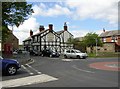
The Farmers' Arms and the remains of a malthouse, Garstang
The map of 1893 shows a malthouse next to the inn, which partly explains the shuttered openings in the stone wall. There was another public house near to the centre of the roundabout.
Image: © Humphrey Bolton
Taken: 14 May 2007
0.02 miles
3
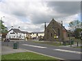
The Wheatsheaf Inn and the Methodist Chapel, Garstang
The inn faces Back Lane, and was built in the late 18C. The Methodist Chapel was Wesleyan. The inn is a listed building, but not the chapel!
Image: © Humphrey Bolton
Taken: 14 May 2007
0.02 miles
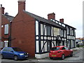
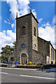
4
St. Thomas's, Garstang
C. of E. parish church, in the diocese of Blackburn.
Image: © philandju
Taken: 23 Jul 2012
0.03 miles
6
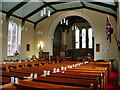
The Parish Church of St Thomas, Garstang, Interior
Image: © Alexander P Kapp
Taken: 3 Sep 2008
0.03 miles
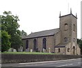
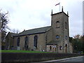
7
The Parish Church of St Thomas, Garstang
The first foundation for the church was laid in 1770. It was built on part of the Royal Oak Field, which was once the town's playground for football matches.
It was rebuilt in 1874 and achieved Parish Church status in 1881.
Image: © David Dixon
Taken: 26 Jul 2011
0.03 miles
9
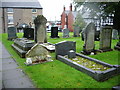
The Parish Church of St Thomas, Garstang, Graveyard
Image: © Alexander P Kapp
Taken: 3 Sep 2008
0.04 miles
10
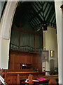
The Parish Church of St Thomas, Garstang, Organ
Image: © Alexander P Kapp
Taken: 3 Sep 2008
0.04 miles