IMAGES TAKEN NEAR TO
Wyreside, PRESTON, PR3 6TP
Introduction
This page details the photographs taken nearby to Wyreside, PR3 6TP by members of the Geograph project.
The Geograph project started in 2005 with the aim of publishing, organising and preserving representative images for every square kilometre of Great Britain, Ireland and the Isle of Man.

There are currently over 7.5m images from over14,400 individuals and you can help contribute to the project by visiting https://www.geograph.org.uk
Image Map (Loading...)


Getting Data...Please wait
Leaflet Map data © OpenStreetMap
Images are licensed for reuse under creativecommons.org/licenses/by-sa/2.0
Notes
- Clicking on the map will re-center to the selected point.
- The higher the marker number, the further away the image location is from the centre of the postcode.
Image Listing (5 Images Found)
Images are licensed for reuse under creativecommons.org/licenses/by-sa/2.0
Image
Details
Distance
1
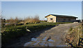
Entrance to new fishing lake at Crane Hall
Image: © Tom Richardson
Taken: 26 Dec 2008
0.12 miles
3
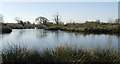
Fishing lake near Crane Hall
Not yet marked on the OS map
Image: © Tom Richardson
Taken: 26 Dec 2008
0.12 miles
4
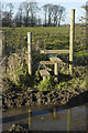
Stile near Crane hall
The stile carries the Wyre Way across a very muddy Crow Lane
Image: © Tom Richardson
Taken: 26 Dec 2008
0.16 miles
