IMAGES TAKEN NEAR TO
Lancaster Road, PRESTON, PR3 6SQ
Introduction
This page details the photographs taken nearby to Lancaster Road, PR3 6SQ by members of the Geograph project.
The Geograph project started in 2005 with the aim of publishing, organising and preserving representative images for every square kilometre of Great Britain, Ireland and the Isle of Man.

There are currently over 7.5m images from over14,400 individuals and you can help contribute to the project by visiting https://www.geograph.org.uk
Image Map
Images are licensed for reuse under creativecommons.org/licenses/by-sa/2.0
Notes
- Clicking on the map will re-center to the selected point.
- The higher the marker number, the further away the image location is from the centre of the postcode.
Image Listing (21 Images Found)
Images are licensed for reuse under creativecommons.org/licenses/by-sa/2.0
Image
Details
Distance
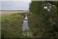
1

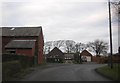
Scronkey
Looking west along Lancaster Road
Image: © Tom Richardson
Taken: 28 Jun 2009
0.01 miles
2
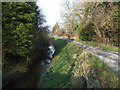
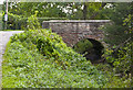
Drain and track
Looking north, Clow's Bridge.
Image: © JThomas
Taken: 29 Nov 2014
0.03 miles

4
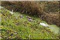
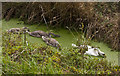
A swan family (2)
An unlikely seeming location, but they are clearly relishing the green algae
Image: © Ian Greig
Taken: 25 Sep 2018
0.03 miles
5
A swan family
An unlikely seeming location, but they are clearly relishing the green algae
Image: © Ian Greig
Taken: 25 Sep 2018
0.03 miles
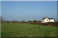
8
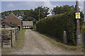
Public footpath to Pilling
The start of the path at Scronkey
Image: © Tom Richardson
Taken: 28 Jun 2009
0.04 miles