IMAGES TAKEN NEAR TO
Green Dicks Lane, PRESTON, PR3 6HR
Introduction
This page details the photographs taken nearby to Green Dicks Lane, PR3 6HR by members of the Geograph project.
The Geograph project started in 2005 with the aim of publishing, organising and preserving representative images for every square kilometre of Great Britain, Ireland and the Isle of Man.

There are currently over 7.5m images from over14,400 individuals and you can help contribute to the project by visiting https://www.geograph.org.uk
Image Map
Images are licensed for reuse under creativecommons.org/licenses/by-sa/2.0
Notes
- Clicking on the map will re-center to the selected point.
- The higher the marker number, the further away the image location is from the centre of the postcode.
Image Listing (8 Images Found)
Images are licensed for reuse under creativecommons.org/licenses/by-sa/2.0
Image
Details
Distance
1
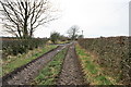
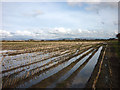
Muddy Lane to Carr House Farm
This is a relatively dry section, after a relatively dry period of weather. Around the corner the lane is flooded.
Image: © Bob Jenkins
Taken: 13 Feb 2009
0.07 miles
3
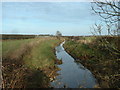
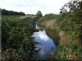
Cocker's Dyke
Labelled 'drain' on the map. It is one of many such dykes draining Pilling Moss.
Image: © David Medcalf
Taken: 21 Jan 2006
0.20 miles
5
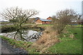
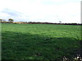
Stubble field near Carr House Farm
The spire of Pilling Church just visible beyond the trees.
Image: © Karl and Ali
Taken: 17 Mar 2012
0.21 miles
7
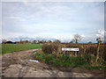
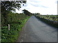
Green Dick's Lane at Muffy's Platt
And what's so funny? I suppose you think Tongues Farm and Fanny Bridge are amusing too?
Image: © Karl and Ali
Taken: 17 Mar 2012
0.22 miles