IMAGES TAKEN NEAR TO
Gardeners Close, PRESTON, PR3 6DA
Introduction
This page details the photographs taken nearby to Gardeners Close, PR3 6DA by members of the Geograph project.
The Geograph project started in 2005 with the aim of publishing, organising and preserving representative images for every square kilometre of Great Britain, Ireland and the Isle of Man.

There are currently over 7.5m images from over14,400 individuals and you can help contribute to the project by visiting https://www.geograph.org.uk
Image Map
Images are licensed for reuse under creativecommons.org/licenses/by-sa/2.0
Notes
- Clicking on the map will re-center to the selected point.
- The higher the marker number, the further away the image location is from the centre of the postcode.
Image Listing (30 Images Found)
Images are licensed for reuse under creativecommons.org/licenses/by-sa/2.0
Image
Details
Distance
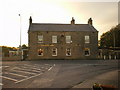

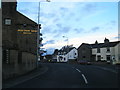
4
Elletson Arms
The disused Elletson Arms public house.
Image: © Peter McDermott
Taken: 8 Oct 2016
0.05 miles
5
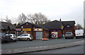
Post Office and stores, Stake Pool
On Lancaster Road.
Image: © JThomas
Taken: 29 Nov 2014
0.05 miles
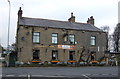
7
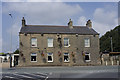
The Elletson Arms, Stakepool, Pilling
Image: © Tom Richardson
Taken: 28 Jun 2009
0.05 miles
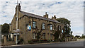
8
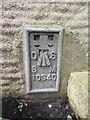
Ordnance Survey Flush Bracket (10340)
This OS Flush Bracket can be found on the Elletson Arms. It marks a point 6.077m above mean sea level.
Image: © Adrian Dust
Taken: 4 Apr 2014
0.05 miles

10
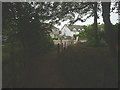
Footpath approaching Lancaster Road, Stakepool
Image: © Karl and Ali
Taken: 12 Jun 2018
0.06 miles