IMAGES TAKEN NEAR TO
Ashford Crescent, PRESTON, PR3 5JU
Introduction
This page details the photographs taken nearby to Ashford Crescent, PR3 5JU by members of the Geograph project.
The Geograph project started in 2005 with the aim of publishing, organising and preserving representative images for every square kilometre of Great Britain, Ireland and the Isle of Man.

There are currently over 7.5m images from over14,400 individuals and you can help contribute to the project by visiting https://www.geograph.org.uk
Image Map (Loading...)


Getting Data...Please wait
Leaflet Map data © OpenStreetMap
Images are licensed for reuse under creativecommons.org/licenses/by-sa/2.0
Notes
- Clicking on the map will re-center to the selected point.
- The higher the marker number, the further away the image location is from the centre of the postcode.
Image Listing (23 Images Found)
Images are licensed for reuse under creativecommons.org/licenses/by-sa/2.0
Image
Details
Distance
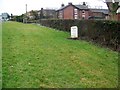
4
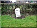
Bench Mark, Preston 4
Pivot bench mark on the top of milestone. For wider views see Image and Image and http://www.bench-marks.org.uk/bm29537
A bench mark is an Ordnance Survey arrowhead sign found on walls, bridges, churches and specially erected triangulation pillars where the altitude above sea-level has been accurately measured by surveyors. The arrowhead points to a horizontal line above it which marks the exact altitude.
With rivets and pivots there is no datum (horizontal line) cut, the pointed-to horizontal surface defining the datum height.
Thanks goes to fellow Geograph member Roger Templeman with whose help I am beginning to learn the finer points of Ordnance Survey bench marks.
Image: © Maigheach-gheal
Taken: 22 Mar 2010
0.19 miles
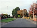
5
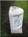
Old Milestone by Garstang Road, north of Broughton
Metal plate attached to stone post by the former A6, in parish of Barton (Preston District), Garstang Road; just North of Broughton, in lay-by 50m North of Helms Farm, on wide cut grass verge between lay-by and hedge, on West side of road. Garstang flowing text, erected by the Preston & Garstang turnpike trust in the 19th century.
Inscription reads:-
: To / Garstang / 6¾ / Miles : : BARTON : : To / Preston / 4 / Miles :
Pivot benchmark with datum line on top.
Grade II listed.
List Entry Number: 1361644 https://historicengland.org.uk/listing/the-list/list-entry/1361644
Milestone Society National ID: LA_PSGS04
Image: © A Rosevear
Taken: 14 Jan 2004
0.19 miles
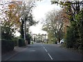
6
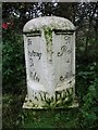
Milestone, Broughton
The milestone erected by the Preston and Garstang Turnpike Trust which was established in 1751.
Turnpikes were administered by turnpike trusts, which were authorised by private act of parliament. The trusts laid down a network of soundly constructed roads throughout the country, replacing parochial maintenance system on many highways and substantially improving communications. The first English turnpike roads were authorised by an act of 1663. By the 1880s there were about 8000 tollgates and 22,000 miles of highway. The trusts engineers, notably John Macadam, constructed many new roads, which by the 1800s were being utilized by an efficient stagecoach system. However, railway expansion after 1830 led to the rapid decline of stagecoaches and turnpike revenue.
For a wider view of the milestone see Image The stone also has a bench mark on its top.
Image: © Maigheach-gheal
Taken: 22 Mar 2010
0.19 miles
7
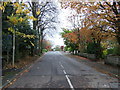
Milestone, Broughton
Milestone standing on the wide verge beside the A6.
Image: © Maigheach-gheal
Taken: 22 Mar 2010
0.19 miles
8
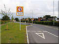
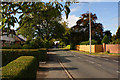
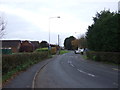
Broughton, Garstang Road
Prior to the opening of the Broughton bypass in October 2017, this was a very congested section of the A6.
Image: © David Dixon
Taken: 27 May 2019
0.20 miles