IMAGES TAKEN NEAR TO
Woodlands Crescent, PRESTON, PR3 5HB
Introduction
This page details the photographs taken nearby to Woodlands Crescent, PR3 5HB by members of the Geograph project.
The Geograph project started in 2005 with the aim of publishing, organising and preserving representative images for every square kilometre of Great Britain, Ireland and the Isle of Man.

There are currently over 7.5m images from over14,400 individuals and you can help contribute to the project by visiting https://www.geograph.org.uk
Image Map
Images are licensed for reuse under creativecommons.org/licenses/by-sa/2.0
Notes
- Clicking on the map will re-center to the selected point.
- The higher the marker number, the further away the image location is from the centre of the postcode.
Image Listing (13 Images Found)
Images are licensed for reuse under creativecommons.org/licenses/by-sa/2.0
Image
Details
Distance
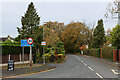
1
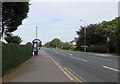
Garstang Road, Barton
The A6 at its junction with Station Lane.
Image: © philandju
Taken: 4 Sep 2013
0.10 miles
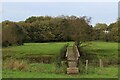
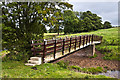
3
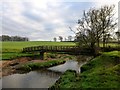
Footbridge Over Barton Brook
Walked from Barton into Black Fir Wood then into pasture before arriving at this footbridge across the Barton Brook. Barton Hall is hidden behind the tree.
Image: © Rude Health
Taken: 18 Dec 2012
0.13 miles
4
Footbridge over Barton Brook
Following a footpath westward to the village of Barton from the M6
Image: © Chris Heaton
Taken: 31 Oct 2022
0.13 miles
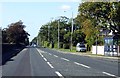
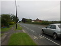
5
Station Lane, Barton
Heads west from the A6 in Barton, towards where the station once stood.
Image: © Chris Heaton
Taken: 31 Oct 2022
0.13 miles
8
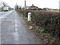
Milestone, Newsham
Milestone beside the A6 midway between Newsham and Barton.
Image: © Maigheach-gheal
Taken: 22 Mar 2010
0.21 miles
9
Milestone, Newsham
The milestone erected by the Preston and Garstang Turnpike Trust which was established in 1751.
Turnpikes were administered by turnpike trusts, which were authorised by private act of parliament. The trusts laid down a network of soundly constructed roads throughout the country, replacing parochial maintenance system on many highways and substantially improving communications. The first English turnpike roads were authorised by an act of 1663. By the 1880s there were about 8000 tollgates and 22,000 miles of highway. The trusts engineers, notably John Macadam, constructed many new roads, which by the 1800s were being utilized by an efficient stagecoach system. However, railway expansion after 1830 led to the rapid decline of stagecoaches and turnpike revenue.
For a wider view of the milestone see Image The milestone has a bench mark on its top.
Image: © Maigheach-gheal
Taken: 22 Mar 2010
0.22 miles
10
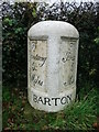
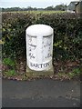
Old Milestone by the A6, Garstang Road, Barton parish
Metal plates attached to stone post by the A6, in parish of BARTON (PRESTON District), Garstang Road, opposite No 650, in front of hedge, on West side of road. Garstang flowing text, erected by the Preston & Garstang turnpike trust in the 19th century.
Inscription reads:-
: To / Garstang / 5¾ / Miles : : BARTON : : To / Preston / 5 / Miles :
Grade II listed.
List Entry Number: 1073557 https://historicengland.org.uk/listing/the-list/list-entry/1073557
Milestone Society National ID: LA_PSGS05.
Image: © C Marcus
Taken: 1 Apr 2008
0.22 miles