IMAGES TAKEN NEAR TO
Chaffinch Manor, PRESTON, PR3 5BE
Introduction
This page details the photographs taken nearby to Chaffinch Manor, PR3 5BE by members of the Geograph project.
The Geograph project started in 2005 with the aim of publishing, organising and preserving representative images for every square kilometre of Great Britain, Ireland and the Isle of Man.

There are currently over 7.5m images from over14,400 individuals and you can help contribute to the project by visiting https://www.geograph.org.uk
Image Map
Images are licensed for reuse under creativecommons.org/licenses/by-sa/2.0
Notes
- Clicking on the map will re-center to the selected point.
- The higher the marker number, the further away the image location is from the centre of the postcode.
Image Listing (6 Images Found)
Images are licensed for reuse under creativecommons.org/licenses/by-sa/2.0
Image
Details
Distance
1
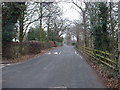
Traffic calming in D'Urton Lane, Broughton
This used to be a convenient short cut, avoiding the Motorway junction, but now has chicanes and traffic humps to deter casual users.
Image: © David Medcalf
Taken: 6 Feb 2006
0.10 miles
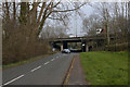
4
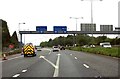
Gantry over the A6 slip road from the M55
Image: © Anthony Parkes
Taken: 25 Oct 2014
0.16 miles
6
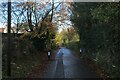
D'Urton Lane
Now a quiet backwater and part of the Preston Guild Wheel cycle route.
Image: © Chris Heaton
Taken: 19 Nov 2022
0.23 miles