IMAGES TAKEN NEAR TO
Garstang Road, PRESTON, PR3 5AB
Introduction
This page details the photographs taken nearby to Garstang Road, PR3 5AB by members of the Geograph project.
The Geograph project started in 2005 with the aim of publishing, organising and preserving representative images for every square kilometre of Great Britain, Ireland and the Isle of Man.

There are currently over 7.5m images from over14,400 individuals and you can help contribute to the project by visiting https://www.geograph.org.uk
Image Map
Images are licensed for reuse under creativecommons.org/licenses/by-sa/2.0
Notes
- Clicking on the map will re-center to the selected point.
- The higher the marker number, the further away the image location is from the centre of the postcode.
Image Listing (17 Images Found)
Images are licensed for reuse under creativecommons.org/licenses/by-sa/2.0
Image
Details
Distance
1
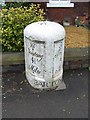
Milestone near Barton
The milestone erected by the Preston and Garstang Turnpike Trust which was established in 1751.
Turnpikes were administered by turnpike trusts, which were authorised by private act of parliament. The trusts laid down a network of soundly constructed roads throughout the country, replacing parochial maintenance system on many highways and substantially improving communications. The first English turnpike roads were authorised by an act of 1663. By the 1880s there were about 8000 tollgates and 22,000 miles of highway. The trusts engineers, notably John Macadam, constructed many new roads, which by the 1800s were being utilized by an efficient stagecoach system. However, railway expansion after 1830 led to the rapid decline of stagecoaches and turnpike revenue.
For a wider view of the milestone Image
Image: © Maigheach-gheal
Taken: 22 Mar 2010
0.01 miles
2
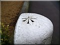
Bench Mark, Preston 6
Rivet bench mark on top of milestone. For a wider view see Image and Image and http://www.bench-marks.org.uk/bm29538
A bench mark is an Ordnance Survey arrowhead sign found on walls, bridges, churches and specially erected triangulation pillars where the altitude above sea-level has been accurately measured by surveyors. The arrowhead points to a horizontal line above it which marks the exact altitude.
With rivets and pivots there is no datum (horizontal line) cut, the pointed-to horizontal surface defining the datum height.
Image: © Maigheach-gheal
Taken: 22 Mar 2010
0.01 miles
3
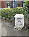
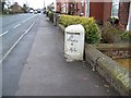
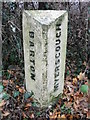
Old Milestone by the A6, Garstang Road, Barton parish
Metal plates attached to stone post by the A6, in parish of BARTON (PRESTON District), Garstang Road; in front of No. 933, just North of White Horse PH, in tarmac path with back to garden hedge and wall, on West side of road. Garstang flowing text, erected by the Preston & Garstang turnpike trust in the 19th century.
Inscription reads:-
: To / Garstang / 4¾ / Miles : : BARTON : : To / Preston / 6 / Miles :
Carved benchmark and rivet on top.
Grade II listed.
List Entry Number: 1073558 https://historicengland.org.uk/listing/the-list/list-entry/1073558
Milestone Society National ID: LA_PSGS06.
Image: © Gail Fawcett
Taken: 21 Oct 2023
0.01 miles
4
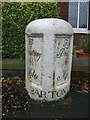
Old Milestone by the A6, Garstang Road, Barton parish
Metal plates attached to stone post by the A6, in parish of BARTON (PRESTON District), Garstang Road; in front of No. 933, just North of White Horse PH, in tarmac path with back to garden hedge and wall, on West side of road. Garstang flowing text, erected by the Preston & Garstang turnpike trust in the 19th century.
Inscription reads:-
: To / Garstang / 4¾ / Miles : : BARTON : : To / Preston / 6 / Miles :
Carved benchmark and rivet on top.
Grade II listed.
List Entry Number: 1073558 https://historicengland.org.uk/listing/the-list/list-entry/1073558
Milestone Society National ID: LA_PSGS06.
Image: © A Rosevear
Taken: 14 Jan 2004
0.01 miles
6
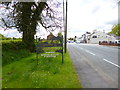
Milestone near Barton
The milestone stands beside the A6 near the village of Barton.
Image: © Maigheach-gheal
Taken: 22 Mar 2010
0.02 miles
7
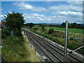
London to Glasgow
London to Glasgow railway, north side of the A6 bridge at Barton
Image: © Alexander P Kapp
Taken: 27 Jul 2006
0.04 miles
8
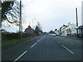
Barton, welcome sign
On Garstang Road (A6).
Image: © Mike Faherty
Taken: 16 May 2012
0.05 miles
9
Old Boundary Marker by the A6, south of Myerscough Cottage
Parish Boundary Marker by the A6, in parish of Barton (Preston District), South of Myerscough Cottage, West side of road.
Inscription reads vertically:-
: BARTON : : MYERSCOUGH :
Surveyed
Milestone Society National ID: LA_PSGS06pb
Image: © Milestone Society
Taken: Unknown
0.05 miles
10
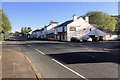
Garstang Road, Barton Bangla Brasserie
Indian restaurant on the A6 at Barton.
Image: © David Dixon
Taken: 11 May 2019
0.07 miles