IMAGES TAKEN NEAR TO
Eastgate, PRESTON, PR3 3ZN
Introduction
This page details the photographs taken nearby to Eastgate, PR3 3ZN by members of the Geograph project.
The Geograph project started in 2005 with the aim of publishing, organising and preserving representative images for every square kilometre of Great Britain, Ireland and the Isle of Man.

There are currently over 7.5m images from over14,400 individuals and you can help contribute to the project by visiting https://www.geograph.org.uk
Image Map
Images are licensed for reuse under creativecommons.org/licenses/by-sa/2.0
Notes
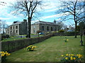
- Clicking on the map will re-center to the selected point.
- The higher the marker number, the further away the image location is from the centre of the postcode.
Image Listing (71 Images Found)
Images are licensed for reuse under creativecommons.org/licenses/by-sa/2.0
Image
Details
Distance
2
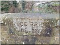
Old Boundary Marker
Bridge Marker set in the west bridge parapet of Boyce's Bridge, Boyce's Brook. RIBCHESTER parish. Inscribed BOYCE BRIDGE / A.D. 1876.
Milestone Society National ID: LA_RIBC01br
Image: © D Phillips
Taken: 27 Dec 2019
0.10 miles
3
House, Stoneygate Lane, Ribchester
Not sure whether this is a new build or a conversion?
Image: © Tom Richardson
Taken: 17 Mar 2011
0.13 miles
5
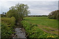
Boyce's Brook
Looking upstream from the edge of Ribchester.
Image: © Bill Boaden
Taken: 5 May 2012
0.15 miles
6
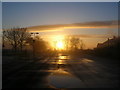
Empty Car Park on Christmas Day
The main car park at Ribchester is deserted in the late afternoon of Christmas Day 2007.
Image: © John H Darch
Taken: 25 Dec 2007
0.15 miles
7
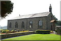
St Peter & St Paul, Stydd, Ribchester
Image: © Alexander P Kapp
Taken: 6 Sep 2005
0.15 miles
8
St Peter & St Paul, Stydd, Ribchester
Image: © Alexander P Kapp
Taken: 6 Sep 2005
0.16 miles
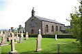
9
St. Peter and St. Paul's RC Church
This church was built in 1789 on the northern outskirts of Ribchester village. It is a so-called "barn church" because Catholicism was still illegal and so it was prudent to disguise the church as a farm building. Ribchester Alms Houses are just out of shot to the right and the ancient Stydd chapel is a few hundred yards to the North West.
Image: © Peter
Taken: 15 Apr 2006
0.16 miles
10
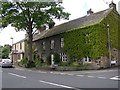
Houses, Blackburn Road, Ribchester
The English Heritage listing states that the central house of the row in the foreground was probably built in the early 18C. The windows still have mullions and transoms. The creeper-covered house on the right was evidently built later, as it blocks a mullioned window in the east attic wall of the central house. The house obscured by the tree has 19C windows and door surround. The new-looking house to the left has had a 'face-lift'; it was the post-office.
Image: © Humphrey Bolton
Taken: 14 May 2007
0.17 miles