IMAGES TAKEN NEAR TO
Fleet Street Lane, PRESTON, PR3 3ZA
Introduction
This page details the photographs taken nearby to Fleet Street Lane, PR3 3ZA by members of the Geograph project.
The Geograph project started in 2005 with the aim of publishing, organising and preserving representative images for every square kilometre of Great Britain, Ireland and the Isle of Man.

There are currently over 7.5m images from over14,400 individuals and you can help contribute to the project by visiting https://www.geograph.org.uk
Image Map
Images are licensed for reuse under creativecommons.org/licenses/by-sa/2.0
Notes
- Clicking on the map will re-center to the selected point.
- The higher the marker number, the further away the image location is from the centre of the postcode.
Image Listing (23 Images Found)
Images are licensed for reuse under creativecommons.org/licenses/by-sa/2.0
Image
Details
Distance
5
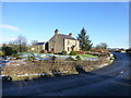
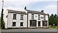
House on Fleet Street Lane at Frances Green
Image: © Raymond Knapman
Taken: 11 Dec 2017
0.15 miles
6
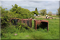
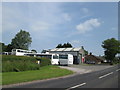
Abandoned Oil Tanks at Buckley Gate
Pasture next to the B6245 containing an assortment of abandoned relics and general rubbish
Image: © Chris Heaton
Taken: 15 May 2020
0.17 miles
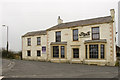
8
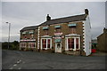
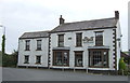
Pane E Vino
This was once the Cross Keys (PH) before the change over.
Image: © Alexander P Kapp
Taken: 12 Jan 2006
0.18 miles
9
Angels Restaurant
Chic cosmopolitan dining in the heart of the Ribble Valley.
Image: © Rude Health
Taken: 21 Apr 2014
0.18 miles