IMAGES TAKEN NEAR TO
Church Street, PRESTON, PR3 3WA
Introduction
This page details the photographs taken nearby to Church Street, PR3 3WA by members of the Geograph project.
The Geograph project started in 2005 with the aim of publishing, organising and preserving representative images for every square kilometre of Great Britain, Ireland and the Isle of Man.

There are currently over 7.5m images from over14,400 individuals and you can help contribute to the project by visiting https://www.geograph.org.uk
Image Map (Loading...)


Getting Data...Please wait
Leaflet Map data © OpenStreetMap
Images are licensed for reuse under creativecommons.org/licenses/by-sa/2.0
Notes
- Clicking on the map will re-center to the selected point.
- The higher the marker number, the further away the image location is from the centre of the postcode.
Image Listing (100 Images Found)
Images are licensed for reuse under creativecommons.org/licenses/by-sa/2.0
Image
Details
Distance
1
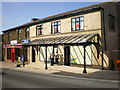
Lord Street, Southport comes to Longridge
New shop front which is typical of Lord Street Southport
Image: © Alexander P Kapp
Taken: 24 Jun 2009
0.01 miles
2
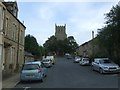
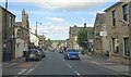
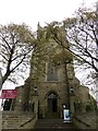
Church Street, Longridge
St Paul's Church at the top.
Image: © JThomas
Taken: 1 Oct 2016
0.01 miles
4
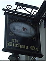
Sign for the Durham Ox public house, Longridge
Image: © JThomas
Taken: 1 Oct 2016
0.02 miles

7
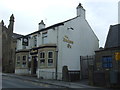
The Durham Ox public house, Longridge
On Berry Lane.
Image: © JThomas
Taken: 1 Oct 2016
0.03 miles
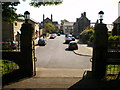
8
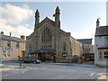
Christ Church Methodist Church, Berry Lane
Image: © David Dixon
Taken: 26 May 2013
0.03 miles
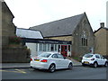
10
St. Pauls Church, Longridge
Church of England parish church.
Image: © philandju
Taken: 31 Oct 2014
0.04 miles