IMAGES TAKEN NEAR TO
St. Marys Close, PRESTON, PR3 3NW
Introduction
This page details the photographs taken nearby to St. Marys Close, PR3 3NW by members of the Geograph project.
The Geograph project started in 2005 with the aim of publishing, organising and preserving representative images for every square kilometre of Great Britain, Ireland and the Isle of Man.

There are currently over 7.5m images from over14,400 individuals and you can help contribute to the project by visiting https://www.geograph.org.uk
Image Map (75 Images)


Getting Data...Please wait
Leaflet Map data © OpenStreetMap
Images are licensed for reuse under creativecommons.org/licenses/by-sa/2.0
Notes
- Clicking on the map will re-center to the selected point.
- The higher the marker number, the further away the image location is from the centre of the postcode.
Image Listing (75 Images Found)
Images are licensed for reuse under creativecommons.org/licenses/by-sa/2.0
Image
Details
Distance
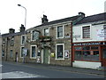
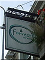
2
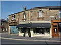
Forrest Arms, Derby Road, Longridge
Image: © Alexander P Kapp
Taken: 21 May 2008
0.04 miles
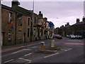
8
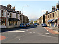
Road junction
Junction of Derby Road and Berry Lane
Image: © Alexander P Kapp
Taken: 21 May 2008
0.05 miles
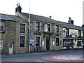
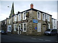
10
Last building on, Berry Lane, Longridge
Image: © Alexander P Kapp
Taken: 1 Sep 2010
0.07 miles