1
Longridge, Berry Lane
Looking NW, near the centre of this square
Image: © Chris Shaw
Taken: Unknown
0.03 miles
2
Longridge
School, pub and church at South end of Berry Lane
Image: © Chris Shaw
Taken: Unknown
0.03 miles
3
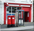
Two Elizabeth II postboxes outside Longridge Post Office
Postbox No. PR3 521 and Postbox No. PR3 522.
See
Image] for context.
Image: © JThomas
Taken: 1 Oct 2016
0.05 miles
4
Longridge Post Office
On Berry Lane.
Showing position of Postbox No. PR3 521 and Postbox No. PR3 522.
See
Image] for postboxes.
Image: © JThomas
Taken: 1 Oct 2016
0.05 miles
5
Millennium Stone Cross, Longridge
"The symbols represent 2000 years of Christianity and the history of Longridge set in the sands of time.
Greek symbol of a fish, the earliest sign of Christianity
Celtic Head, the earliest inhabitants of Longridge
Sheep, early farming culture in the area
Church, St Lawrence’s, the first in the town
Bulls Head from Longridge’s town crest, symbolises agriculture
Horse drawn quarry wagon, the local stone industry
Steam Train, 19th century link made possible the town’s expansion
Church, Alston Lane RC Church
Four Mills, a century of weaving
On the edge, a rope links a Lancashire rose on one side, to a weaver’s shuttle on the other
Ginger the cat, curled up and not far from the spot where he used to sleep
Sculptor’s signature, Boris Howarth
This cross marks the start of the Longridge Heritage Trails."
(from the plaque, nearby)
Image: © David Dixon
Taken: 26 May 2013
0.06 miles
6
The Millennium Stone Cross
Image: © Ian Greig
Taken: 22 May 2015
0.06 miles
7
Lord Street, Southport comes to Longridge
New shop front which is typical of Lord Street Southport
Image: © Alexander P Kapp
Taken: 24 Jun 2009
0.06 miles
8
St. Paul's Church, Longridge
Church harking back from Victorian times.
Image: © Chris Heaton
Taken: 15 May 2020
0.07 miles
9
St Paul's Church, Longridge
The building of St Paul's Church, at the top of Church Street, was completed and it was consecrated in 1890 but it was not until 1937 that the tower was added (http://www.ribblevalley.gov.uk/info/200126/council/839/historic_churches_in_ribble_valley/11 Ribble Valley Borough Council).
Image: © David Dixon
Taken: 26 May 2013
0.07 miles
10
St. Pauls Church, Longridge
Church of England parish church.
Image: © philandju
Taken: 31 Oct 2014
0.07 miles


