IMAGES TAKEN NEAR TO
Mardale Road, PRESTON, PR3 3EU
Introduction
This page details the photographs taken nearby to Mardale Road, PR3 3EU by members of the Geograph project.
The Geograph project started in 2005 with the aim of publishing, organising and preserving representative images for every square kilometre of Great Britain, Ireland and the Isle of Man.

There are currently over 7.5m images from over14,400 individuals and you can help contribute to the project by visiting https://www.geograph.org.uk
Image Map (5 Images)


Getting Data...Please wait
Leaflet Map data © OpenStreetMap
Images are licensed for reuse under creativecommons.org/licenses/by-sa/2.0
Notes
- Clicking on the map will re-center to the selected point.
- The higher the marker number, the further away the image location is from the centre of the postcode.
Image Listing (5 Images Found)
Images are licensed for reuse under creativecommons.org/licenses/by-sa/2.0
Image
Details
Distance
1
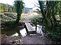
Footbridge Over Savick Brook
I walked down Green Nook Lane towards Lower Green Nook. Just before Lower Green Nook the footpath turns left and goes over the Savick Brook and skirts to the south of the industrial estate.
Image: © Rude Health
Taken: 10 Mar 2013
0.15 miles
2
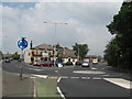
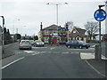
Junction of Chapel Hill with Preston Road, Longridge
Junction of Chapel Hill with Preston Road, Longridge and the Old Oak pub which was built in 1838.
Image: © Sue Adair
Taken: 9 Jun 2007
0.22 miles
3
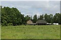
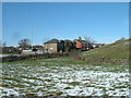
Shay Farm
Arrived here by utilising a footpath that traverses several fields of long grass from Grimsargh - the route is not evident on the ground, making it hard work through knee high vegetation.
Image: © Chris Heaton
Taken: 11 Jun 2022
0.22 miles