IMAGES TAKEN NEAR TO
Doctors Row, PRESTON, PR3 3ES
Introduction
This page details the photographs taken nearby to Doctors Row, PR3 3ES by members of the Geograph project.
The Geograph project started in 2005 with the aim of publishing, organising and preserving representative images for every square kilometre of Great Britain, Ireland and the Isle of Man.

There are currently over 7.5m images from over14,400 individuals and you can help contribute to the project by visiting https://www.geograph.org.uk
Image Map
Images are licensed for reuse under creativecommons.org/licenses/by-sa/2.0
Notes
- Clicking on the map will re-center to the selected point.
- The higher the marker number, the further away the image location is from the centre of the postcode.
Image Listing (14 Images Found)
Images are licensed for reuse under creativecommons.org/licenses/by-sa/2.0
Image
Details
Distance
3
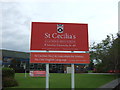
Sign for the St Cecilia's Roman Catholic High School
Image: © JThomas
Taken: 24 Sep 2016
0.09 miles
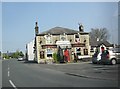
6
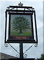
Sign for the Old Oak public house, Longridge
Image: © JThomas
Taken: 24 Sep 2016
0.11 miles
7
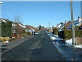
Urban Longridge
A modern housing estate on the south west of Longridge. The road is Hacking Drive, looking north east.
Image: © David Medcalf
Taken: 4 Mar 2006
0.12 miles
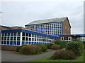
8
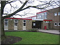
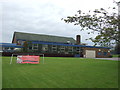
Longridge High School
The main entrance at Longridge High School.
Image: © Chris Preston
Taken: 1 Feb 2006
0.12 miles
9
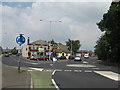
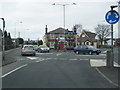
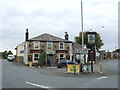
Junction of Chapel Hill with Preston Road, Longridge
Junction of Chapel Hill with Preston Road, Longridge and the Old Oak pub which was built in 1838.
Image: © Sue Adair
Taken: 9 Jun 2007
0.13 miles