IMAGES TAKEN NEAR TO
Betula Drive, PRESTON, PR3 3DF
Introduction
This page details the photographs taken nearby to Betula Drive, PR3 3DF by members of the Geograph project.
The Geograph project started in 2005 with the aim of publishing, organising and preserving representative images for every square kilometre of Great Britain, Ireland and the Isle of Man.

There are currently over 7.5m images from over14,400 individuals and you can help contribute to the project by visiting https://www.geograph.org.uk
Image Map (Loading...)


Getting Data...Please wait
Leaflet Map data © OpenStreetMap
Images are licensed for reuse under creativecommons.org/licenses/by-sa/2.0
Notes
- Clicking on the map will re-center to the selected point.
- The higher the marker number, the further away the image location is from the centre of the postcode.
Image Listing (8 Images Found)
Images are licensed for reuse under creativecommons.org/licenses/by-sa/2.0
Image
Details
Distance
1
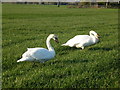
Two Swans In Pasture
These two swans lived beside a small stream in this grass field last spring.
Image: © Rude Health
Taken: 28 Mar 2012
0.05 miles
5
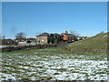
Bird Viewing Point
This bird viewing point is one of two on Pinfold Lane that overlooks a pond which may have something to do with the neighbouring reservoirs. The swans were sleeping this morning but the ducks were playing around.
Image: © Rude Health
Taken: 21 Jan 2013
0.23 miles
7
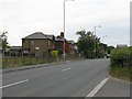
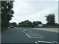
Preston Road, Longridge
The B6243, on the southeastern outskirts of Longridge.
Image: © M J Richardson
Taken: 25 Jun 2010
0.23 miles