IMAGES TAKEN NEAR TO
Higher Road, PRESTON, PR3 2XY
Introduction
This page details the photographs taken nearby to Higher Road, PR3 2XY by members of the Geograph project.
The Geograph project started in 2005 with the aim of publishing, organising and preserving representative images for every square kilometre of Great Britain, Ireland and the Isle of Man.

There are currently over 7.5m images from over14,400 individuals and you can help contribute to the project by visiting https://www.geograph.org.uk
Image Map
Images are licensed for reuse under creativecommons.org/licenses/by-sa/2.0
Notes
- Clicking on the map will re-center to the selected point.
- The higher the marker number, the further away the image location is from the centre of the postcode.
Image Listing (16 Images Found)
Images are licensed for reuse under creativecommons.org/licenses/by-sa/2.0
Image
Details
Distance
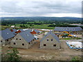
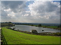
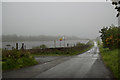
3
Longridge Reservoirs Still Full
It's official. March 2012 was the sunniest, driest on record in the UK. NW England received only 27% of the average monthly rainfall. The NW had 155.4 hours of sunshine, that's 168% of the usual sunshine we'd expect in Granada Region.
The region only had 29.6mm rain which is 27% of the normal amount of rainfall we'd expect for the month.
However as seen from Hill Top, Longridge, the Spade Mill Reservoirs and Alston Reservoirs are still full so no hose pipe ban here.
The new Hen Houses are bedding into their setting now too.
Image: © Rude Health
Taken: 4 Apr 2012
0.14 miles
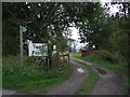
7
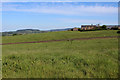
Footpath leading to Stone Croft
The footpath heads north west from Higher Road, crossing two pastures thick with grass to reach Stone Croft on Forty Acre Lane.
Image: © Chris Heaton
Taken: 2 Jun 2020
0.19 miles
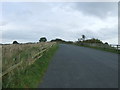
9
"No public access for any reason"
It doesn't look particularly inviting at the moment, anyway.
Image: © Ian Greig
Taken: 22 May 2015
0.19 miles
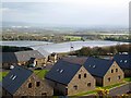
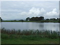
10
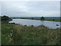
Looking down on Dilworth Reservoir
From Higher Road.
Image: © JThomas
Taken: 1 Oct 2016
0.21 miles