IMAGES TAKEN NEAR TO
Chipping, PRESTON, PR3 2WP
Introduction
This page details the photographs taken nearby to PR3 2WP by members of the Geograph project.
The Geograph project started in 2005 with the aim of publishing, organising and preserving representative images for every square kilometre of Great Britain, Ireland and the Isle of Man.

There are currently over 7.5m images from over14,400 individuals and you can help contribute to the project by visiting https://www.geograph.org.uk
Image Map
Images are licensed for reuse under creativecommons.org/licenses/by-sa/2.0
Notes
- Clicking on the map will re-center to the selected point.
- The higher the marker number, the further away the image location is from the centre of the postcode.
Image Listing (8 Images Found)
Images are licensed for reuse under creativecommons.org/licenses/by-sa/2.0
Image
Details
Distance
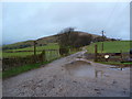
3
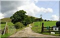
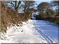
Farm track
The entrance to Higher Core farm.
Image: © philandju
Taken: 27 Jul 2022
0.18 miles
4
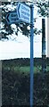
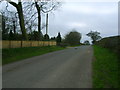
Direction Sign ? Signpost in Chipping
Located behind a modern fingerpost on the north side of the T junction of Startifants Lane and Fiddlers Lane in Chipping parish. No arms or finial.
Milestone Society National ID: LA_SD5943
Image: © D Armstrong
Taken: Unknown
0.18 miles
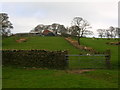
8
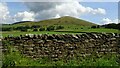
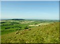
Cattle grazing under Parlick
At Higher Core farm.
Image: © philandju
Taken: 27 Jul 2022
0.22 miles