IMAGES TAKEN NEAR TO
Garstang Road, PRESTON, PR3 2QJ
Introduction
This page details the photographs taken nearby to Garstang Road, PR3 2QJ by members of the Geograph project.
The Geograph project started in 2005 with the aim of publishing, organising and preserving representative images for every square kilometre of Great Britain, Ireland and the Isle of Man.

There are currently over 7.5m images from over14,400 individuals and you can help contribute to the project by visiting https://www.geograph.org.uk
Image Map (Loading...)


Getting Data...Please wait
Leaflet Map data © OpenStreetMap
Images are licensed for reuse under creativecommons.org/licenses/by-sa/2.0
Notes
- Clicking on the map will re-center to the selected point.
- The higher the marker number, the further away the image location is from the centre of the postcode.
Image Listing (13 Images Found)
Images are licensed for reuse under creativecommons.org/licenses/by-sa/2.0
Image
Details
Distance
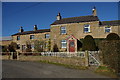
3
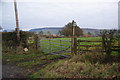
Black Hall Farm
Farming operation to the west of Chipping.
Image: © Chris Heaton
Taken: 16 Apr 2019
0.09 miles
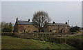
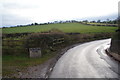
4
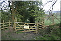
Bridleway by Black Hall Farm
Part of a route to Radcliffe Hall and Longridge Road, skirting Chipping.
Image: © Bill Boaden
Taken: 23 Nov 2013
0.10 miles
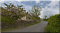
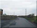
6
Road past Black Hall Farm
The sign warns of children, dogs and elephants. We didn't see any elephants, but we didn't see any children or dogs either.
Image: © Bill Boaden
Taken: 23 Nov 2013
0.13 miles
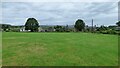
7
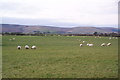
Sheep near Black Hall Farm
The open grazing land has the backdrop of the Bowland fells.
Image: © Bill Boaden
Taken: 23 Nov 2013
0.13 miles
8

Countryside near Halton Hill
Previous Ordnance Survey Maps had this as Holton Hill, while the more up to date series have substituted the "o" with an "a".
Image: © Chris Heaton
Taken: 16 Apr 2019
0.15 miles
9
Down The Bridle Path
The last gate then a left hand turn into Chipping along a narrow lane.
Image: © Alan James
Taken: 24 Apr 2011
0.18 miles