IMAGES TAKEN NEAR TO
Carron Lane, PRESTON, PR3 2LF
Introduction
This page details the photographs taken nearby to Carron Lane, PR3 2LF by members of the Geograph project.
The Geograph project started in 2005 with the aim of publishing, organising and preserving representative images for every square kilometre of Great Britain, Ireland and the Isle of Man.

There are currently over 7.5m images from over14,400 individuals and you can help contribute to the project by visiting https://www.geograph.org.uk
Image Map
Images are licensed for reuse under creativecommons.org/licenses/by-sa/2.0
Notes
- Clicking on the map will re-center to the selected point.
- The higher the marker number, the further away the image location is from the centre of the postcode.
Image Listing (30 Images Found)
Images are licensed for reuse under creativecommons.org/licenses/by-sa/2.0
Image
Details
Distance
1
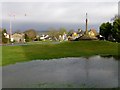
Inglewhite Green
Inglewhite is a small village in the parish of Goosnargh in Lancashire, England. It lies at the intersection of the roads from Longridge to Garstang and from Broughton to Beacon Fell. The Green looks pretty water logged today and doesn't normally have a pond !
The green was traditionally the site of cattle and sheep fairs, but these were stopped in the 19th century by a vicar opposed to the practice of bull baiting. The market cross, dating from 1500, has engraved on its shaft the initials HCIW, dated 1675 and believed to be those of Justice Warren, then Lord of the Manor.
The road names of Button Street and Silk Mill Lane indicate other industries that once thrived near the village. Silk Mill Lane derives its name from a silk mill powered by a waterwheel which once stood adjacent to where the brook crosses the Lane.
Image: © Rude Health
Taken: 1 Jan 2013
0.03 miles
2
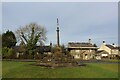
Inglewhite Cross
Grade II Listed market cross, said to have been erected in 1675 - located on the village green
Image: © Chris Heaton
Taken: 5 Feb 2023
0.03 miles
3
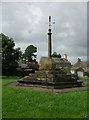
Old Central Cross on Inglewhite village green, Goosnargh parish
Inglewhite Cross, old shaft, base and steps in a new cross, by the wayside, in parish of Goosnargh (Preston District), on Inglewhite village green.
Grade II listed.
List Entry Number: 1073539 https://historicengland.org.uk/listing/the-list/list-entry/1073539
To be surveyed
Milestone Society National ID: LAPR_GOO03
Image: © Milestone Society
Taken: Unknown
0.03 miles
5
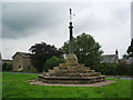
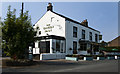
Market Cross
To be found opposite to The Green Man. Cattle used to be bought and sold on the green here. Inscribed with the initials of the Lord of the Manor and the dates when it was erected and renovated.
Image: © Alexander P Kapp
Taken: 6 Aug 2008
0.04 miles
6
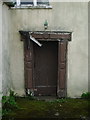
Black Bull Farm, Inglewhite, Doorway
Image: © Alexander P Kapp
Taken: 6 Aug 2008
0.04 miles
7
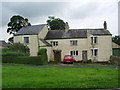
Black Bull Farm and Cottage, Inglewhite
Image: © Alexander P Kapp
Taken: 6 Aug 2008
0.04 miles
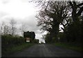
10
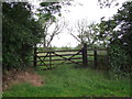
Overgrown field over the 5 barred gate
At Inglewhite. The field seems to be unused. The gate is an unusual style with the vertical stay towards the left.
Image: © Phil and Juliette Platt
Taken: 20 Jun 2011
0.05 miles