IMAGES TAKEN NEAR TO
St. Johns Drive, PRESTON, PR3 2JR
Introduction
This page details the photographs taken nearby to St. Johns Drive, PR3 2JR by members of the Geograph project.
The Geograph project started in 2005 with the aim of publishing, organising and preserving representative images for every square kilometre of Great Britain, Ireland and the Isle of Man.

There are currently over 7.5m images from over14,400 individuals and you can help contribute to the project by visiting https://www.geograph.org.uk
Image Map
Images are licensed for reuse under creativecommons.org/licenses/by-sa/2.0
Notes
- Clicking on the map will re-center to the selected point.
- The higher the marker number, the further away the image location is from the centre of the postcode.
Image Listing (15 Images Found)
Images are licensed for reuse under creativecommons.org/licenses/by-sa/2.0
Image
Details
Distance
1
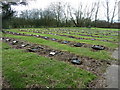
Old cemetery for Whittingham Hospital
Some of the patients here had long lives, one old boy reaching 112 years.
Image: © Peter Bond
Taken: 19 Mar 2011
0.09 miles

3
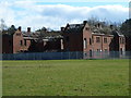
Cameron House, Whittingham Hospital
From the football pitch.
Image: © Peter Bond
Taken: 19 Mar 2011
0.18 miles
4
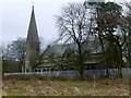
St John's Church, Whittingham Hospital
As with all Victorian Institutions of the day, religion played a great part and, it was to this end that a Church was built within the grounds and was named St John's. The contract for the erection of a Church and a Chaplain's house was awarded in September 1871, estimated costings being £4,632.00 and £1,579. 8s 2d respectively.
The house was subsequently not erected at the time and when it was the cost had risen to £2,000! An organ was purchased and installed in the Church at a cost of £250 and arrangements were made to provide heating by means of hot water, heated by gas.
St John's Church was Church of England, and provision for Roman Catholics was made in a room set aside in one of the wards. In June 1875 the Church was licensed by the Bishop of Manchester. The first hospital chaplain was the Rev W T Palmour. The Asylum cemetery was consecrated in 1895, again by the Bishop of Manchester and the chaplain was subsequently awarded 2/6d for each burial service performed.
High security fencing prevented a closer look. Planning permission given in 2011 for affordable housing for this former asylum site.
Image: © Rude Health
Taken: 30 Dec 2012
0.19 miles
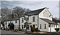
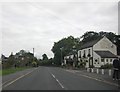
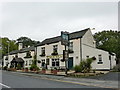
6
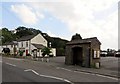
Pub and bus stop in Goosnargh
The Stag's Head.
Image: © philandju
Taken: 22 Aug 2013
0.19 miles