IMAGES TAKEN NEAR TO
Mill Lane, PRESTON, PR3 2FL
Introduction
This page details the photographs taken nearby to Mill Lane, PR3 2FL by members of the Geograph project.
The Geograph project started in 2005 with the aim of publishing, organising and preserving representative images for every square kilometre of Great Britain, Ireland and the Isle of Man.

There are currently over 7.5m images from over14,400 individuals and you can help contribute to the project by visiting https://www.geograph.org.uk
Image Map (Loading...)


Getting Data...Please wait
Leaflet Map data © OpenStreetMap
Images are licensed for reuse under creativecommons.org/licenses/by-sa/2.0
Notes
- Clicking on the map will re-center to the selected point.
- The higher the marker number, the further away the image location is from the centre of the postcode.
Image Listing (5 Images Found)
Images are licensed for reuse under creativecommons.org/licenses/by-sa/2.0
Image
Details
Distance
3
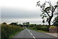
Inglewhite Road heading towards Inglewhite
Image: © Steve Daniels
Taken: 19 Jun 2015
0.20 miles
4
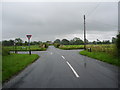
Road junction
The junction of Mill Lane and Syke House Lane with Inglewhite Road
Image: © Alexander P Kapp
Taken: 3 Jul 2007
0.20 miles
5
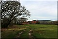
Looking towards Willowdene
Looking north towards the red brick dwelling of Willowdene on Inglewhite Road
Image: © Chris Heaton
Taken: 5 Feb 2023
0.23 miles