IMAGES TAKEN NEAR TO
Stanalee Lane, PRESTON, PR3 2EQ
Introduction
This page details the photographs taken nearby to Stanalee Lane, PR3 2EQ by members of the Geograph project.
The Geograph project started in 2005 with the aim of publishing, organising and preserving representative images for every square kilometre of Great Britain, Ireland and the Isle of Man.

There are currently over 7.5m images from over14,400 individuals and you can help contribute to the project by visiting https://www.geograph.org.uk
Image Map
Images are licensed for reuse under creativecommons.org/licenses/by-sa/2.0
Notes
- Clicking on the map will re-center to the selected point.
- The higher the marker number, the further away the image location is from the centre of the postcode.
Image Listing (16 Images Found)
Images are licensed for reuse under creativecommons.org/licenses/by-sa/2.0
Image
Details
Distance
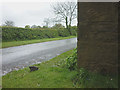
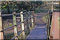
1
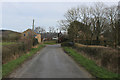
Stanalee Lane
Heading towards Cloggers Farm
Image: © Chris Heaton
Taken: 21 Mar 2020
0.02 miles
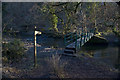
3
Bench mark, Lower Stanalee
At an altitude of 110.021m asl.
Image: © Karl and Ali
Taken: 10 May 2014
0.15 miles
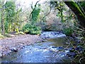
8
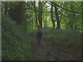
Path through Gill Wood
The steep, stony climb up from the Brock is bordered by bluebells.
Image: © Karl and Ali
Taken: 10 May 2014
0.22 miles