IMAGES TAKEN NEAR TO
Flowerfields, PRESTON, PR3 1YU
Introduction
This page details the photographs taken nearby to Flowerfields, PR3 1YU by members of the Geograph project.
The Geograph project started in 2005 with the aim of publishing, organising and preserving representative images for every square kilometre of Great Britain, Ireland and the Isle of Man.

There are currently over 7.5m images from over14,400 individuals and you can help contribute to the project by visiting https://www.geograph.org.uk
Image Map (Loading...)


Getting Data...Please wait
Leaflet Map data © OpenStreetMap
Images are licensed for reuse under creativecommons.org/licenses/by-sa/2.0
Notes
- Clicking on the map will re-center to the selected point.
- The higher the marker number, the further away the image location is from the centre of the postcode.
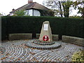
Image Listing (6 Images Found)
Images are licensed for reuse under creativecommons.org/licenses/by-sa/2.0
Image
Details
Distance
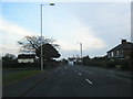
4
Garstang Road approaching Calder Bridge
Image: © Steve Daniels
Taken: 16 Jun 2022
0.22 miles
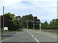
5
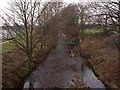
River Calder at Catterall
Looking downstream from Catterall Bridge on the B6430
Image: © David Medcalf
Taken: 8 Jan 2006
0.23 miles
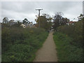
6
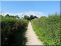
Footpath by the Old Mill Stream
The path runs from Stone Lane in Catterall down to the Lancaster Canal.
Image: © philandju
Taken: 19 Jul 2016
0.23 miles