IMAGES TAKEN NEAR TO
Bleasdale, PRESTON, PR3 1UY
Introduction
This page details the photographs taken nearby to PR3 1UY by members of the Geograph project.
The Geograph project started in 2005 with the aim of publishing, organising and preserving representative images for every square kilometre of Great Britain, Ireland and the Isle of Man.

There are currently over 7.5m images from over14,400 individuals and you can help contribute to the project by visiting https://www.geograph.org.uk
Image Map (Loading...)


Getting Data...Please wait
Leaflet Map data © OpenStreetMap
Images are licensed for reuse under creativecommons.org/licenses/by-sa/2.0
Notes
- Clicking on the map will re-center to the selected point.
- The higher the marker number, the further away the image location is from the centre of the postcode.
Image Listing (18 Images Found)
Images are licensed for reuse under creativecommons.org/licenses/by-sa/2.0
Image
Details
Distance
2

Brooks Farmhouse
The late 17th Century farmhouse is Grade II listed http://www.britishlistedbuildings.co.uk/en-185419-brooks-farmhouse-bleasdale-lancashire
Image: © Karl and Ali
Taken: 17 Nov 2013
0.01 miles
3
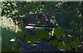
Pack horse bridge at Bleasdale
Carrying a now defunct track over the River Brock. A few metres downstream there was a ford across the river, which is little more than a stream at this stage, but the ford has now been replaced by a road bridge.
Image: © philandju
Taken: 17 Jul 2014
0.02 miles
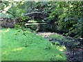
4

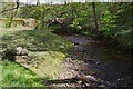
Brooks Farm
Farmyard scene at Brooks, in Bleasdale
Image: © Chris Heaton
Taken: 9 Jun 2018
0.03 miles
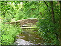
7
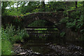
Bleasdale Packhorse Bridge
Crosses the upper reaches of the River Brock.
Recent research suggests this is not a packhorse bridge at all, but a simple pedestrian crossing. The banks on one side are too steep for horses carrying heavy burdens.
It also does not appear on the 1843 Ordnance Survey Map, but does in 1893 - suggesting the structure rather late for the architypical packhorse bridge.
Image: © Chris Heaton
Taken: 9 Jun 2018
0.04 miles
8

Brooks Farm, Bleasdale
Now....Brooks Farm is on the River Brock. It seems that these must be related names....presumably 'Brock comes from 'brook'
Image: © David Medcalf
Taken: 29 Oct 2005
0.04 miles
9
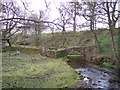
Ancient packhorse bridge at Brooks
The bridge spans the River Brook
Image: © Raymond Knapman
Taken: 16 Apr 2012
0.04 miles
10
Packhorse bridge at Brooks
Over the River Brock. Photo taken from the younger bridge downstream.
Image: © Ian Taylor
Taken: 12 May 2012
0.04 miles