IMAGES TAKEN NEAR TO
Bleasdale, PRESTON, PR3 1UX
Introduction
This page details the photographs taken nearby to PR3 1UX by members of the Geograph project.
The Geograph project started in 2005 with the aim of publishing, organising and preserving representative images for every square kilometre of Great Britain, Ireland and the Isle of Man.

There are currently over 7.5m images from over14,400 individuals and you can help contribute to the project by visiting https://www.geograph.org.uk
Image Map
Images are licensed for reuse under creativecommons.org/licenses/by-sa/2.0
Notes
- Clicking on the map will re-center to the selected point.
- The higher the marker number, the further away the image location is from the centre of the postcode.
Image Listing (11 Images Found)
Images are licensed for reuse under creativecommons.org/licenses/by-sa/2.0
Image
Details
Distance
1
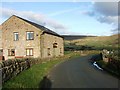
Wickins Barn
With the Bleasedale Fells in the distance.
Image: © Bryan Pready
Taken: 16 Nov 2008
0.01 miles
2
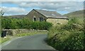
Wickins Barn
The datestone reads G.S. 1850.
Image: © philandju
Taken: 30 Aug 2022
0.01 miles
3
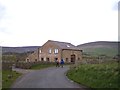
Wickins Barn near Higher Brock Mill
Image: © Raymond Knapman
Taken: 16 Apr 2012
0.01 miles
5
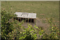
A sheep shelter?
There was a right racket from the field. Through the hedge I could see a dozen or more sheep clambering over and under this box - apparently trying to fight a way inside into the shade. By the time I had found a position to hold my camera, at arms length, above the hedge they'd made themselves scarce.
Image: © Ian Greig
Taken: 3 Jul 2018
0.10 miles
7
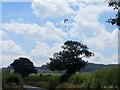
Hang glider near Parlick Fell
The gliders take to the air from Parlick Fell.
Image: © philandju
Taken: 17 Jul 2014
0.14 miles
9
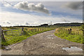
Farm track and Footpath to Sagar's Farm
Image: © Tom Richardson
Taken: 17 Aug 2011
0.20 miles
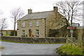
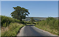
10
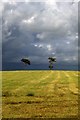
Angry skies and lone trees near Wickin's Barn
Image: © Colin Park
Taken: 11 Jun 1998
0.21 miles