IMAGES TAKEN NEAR TO
Bleasdale, PRESTON, PR3 1UU
Introduction
This page details the photographs taken nearby to PR3 1UU by members of the Geograph project.
The Geograph project started in 2005 with the aim of publishing, organising and preserving representative images for every square kilometre of Great Britain, Ireland and the Isle of Man.

There are currently over 7.5m images from over14,400 individuals and you can help contribute to the project by visiting https://www.geograph.org.uk
Image Map (Loading...)


Getting Data...Please wait
Leaflet Map data © OpenStreetMap
Images are licensed for reuse under creativecommons.org/licenses/by-sa/2.0
Notes
- Clicking on the map will re-center to the selected point.
- The higher the marker number, the further away the image location is from the centre of the postcode.
Image Listing (6 Images Found)
Images are licensed for reuse under creativecommons.org/licenses/by-sa/2.0
Image
Details
Distance
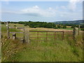
2
Footpath to the former Dog and Partridge
The wood in the middle distance is King Brow Wood. The Bleasdale Fells are spread out in the distance. The indistinct footpath runs alongside the hawthorn hedge at left of shot.
Image: © michael ely
Taken: 6 Mar 2011
0.13 miles
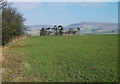
5
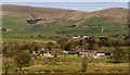
Heatherway Farm
View of Heatherway Farm.
Image: © Peter McDermott
Taken: 18 Apr 2015
0.24 miles
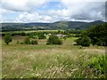
6
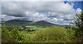
A view Northeast from Beacon Fell
The hills in view are Parlick and to the left the higher Fair Snape Fell.
The vertical line about a quarter of the way from the right is a trick of the light, it's not two shots merged.
Image: © Ian Greig
Taken: 29 May 2015
0.25 miles