IMAGES TAKEN NEAR TO
Lingart Lane, PRESTON, PR3 1RL
Introduction
This page details the photographs taken nearby to Lingart Lane, PR3 1RL by members of the Geograph project.
The Geograph project started in 2005 with the aim of publishing, organising and preserving representative images for every square kilometre of Great Britain, Ireland and the Isle of Man.

There are currently over 7.5m images from over14,400 individuals and you can help contribute to the project by visiting https://www.geograph.org.uk
Image Map (Loading...)


Getting Data...Please wait
Leaflet Map data © OpenStreetMap
Images are licensed for reuse under creativecommons.org/licenses/by-sa/2.0
Notes
- Clicking on the map will re-center to the selected point.
- The higher the marker number, the further away the image location is from the centre of the postcode.
Image Listing (20 Images Found)
Images are licensed for reuse under creativecommons.org/licenses/by-sa/2.0
Image
Details
Distance
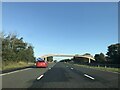
7
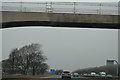
Gantry and Footbridge - M6 Lancashire
Image: © Anthony Parkes
Taken: 8 Sep 2012
0.12 miles
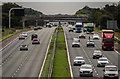
8
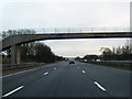
Barnacre-with-Bonds : M6 Motorway
The M6 Motorway between Junction 32 (Broughton Interchange) and Junction 33.
Image: © Lewis Clarke
Taken: 23 Sep 2019
0.15 miles
9
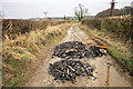
Burnt Offerings on Lingart Lane
On a public footpath.
Image: © Bob Jenkins
Taken: 17 Feb 2009
0.16 miles
10
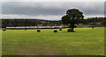
Higher Lingart Farm
Fields on Higher Lingart Farm.
Image: © Peter McDermott
Taken: 8 Oct 2016
0.16 miles