IMAGES TAKEN NEAR TO
Bowland View, PRESTON, PR3 1LR
Introduction
This page details the photographs taken nearby to Bowland View, PR3 1LR by members of the Geograph project.
The Geograph project started in 2005 with the aim of publishing, organising and preserving representative images for every square kilometre of Great Britain, Ireland and the Isle of Man.

There are currently over 7.5m images from over14,400 individuals and you can help contribute to the project by visiting https://www.geograph.org.uk
Image Map
Images are licensed for reuse under creativecommons.org/licenses/by-sa/2.0
Notes
- Clicking on the map will re-center to the selected point.
- The higher the marker number, the further away the image location is from the centre of the postcode.
Image Listing (13 Images Found)
Images are licensed for reuse under creativecommons.org/licenses/by-sa/2.0
Image
Details
Distance
2
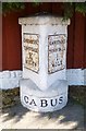
Old Milestone by the B6430, Lancaster Road, Garstang
Metal plates attached to stone post by the B6430 (was A6), in parish of GARSTANG (WYRE District), Lancaster Road; opposite No. 101, 20m South of junction with Green Lane, in pavement, back to a new wooden domestic fence, on West side of road. Lancaster twin iron plate, erected by the Garstang & Heronsyke turnpike trust in the 19th century.
Inscription reads:-
: LANCASTER / TOWN HALL / X / MILES : : CABUS : : GARSTANG / TOWN HALL / ¾ / MILE :
Carved bench mark and rivet on top.
Grade II listed.
List Entry Number: 1361935 https://historicengland.org.uk/listing/the-list/list-entry/1361935
Milestone Society National ID: LA_LAGS10.
Image: © A Rosevear
Taken: 7 Sep 2003
0.11 miles
3
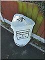
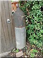
OS Bench Mark
OS rivet bench mark on top of old milestone. 23.53 m above datum. This one seems to have acquired an extra stroke on its arrow.
Image: © Phil Johnstone
Taken: 1 Mar 2022
0.12 miles
4

Old Boundary Marker on the B6430 in Garstang
Parish Boundary Marker by the B6430, in parish of Garstang (Wyre District), Lancaster Road/High Street; between No. 39 and "Milestones", in pavement back to low stone boundary wall.
Inscription reads:-
: Garstang : : Cabus :
Grade II listed.
List Entry Number: 1318134 https://historicengland.org.uk/listing/the-list/list-entry/1318134
Surveyed
Milestone Society National ID: LA_LAGS10pb
Image: © D Garside
Taken: Unknown
0.12 miles
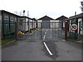
6
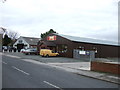
Industrial units, Green Lane West, Garstang
Image: © JThomas
Taken: 16 Nov 2013
0.19 miles
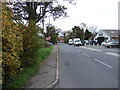
9
Bollards
Placed here on Green Lane to stop vehicular traffic which used to use the narrow lane as a short cut.
Image: © Bob Jenkins
Taken: 29 Jan 2009
0.21 miles
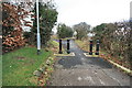
10
Toll Gate Gatepost, Lancaster Road, Garstang
The original 1824 gatepost (pier) with iron pivot on top, on the old A6
This sits on the South side of Image
Opposite a re-modelled Roman milestone that served as the other gatepost see Image
More information can be read at https://lancashirepast.com/2021/09/18/garstang-toll-house-and-roman-milestone/.
Image: © Hilary Jones
Taken: 13 Jul 2023
0.23 miles