IMAGES TAKEN NEAR TO
Oakenclough Road, PRESTON, PR3 1DH
Introduction
This page details the photographs taken nearby to Oakenclough Road, PR3 1DH by members of the Geograph project.
The Geograph project started in 2005 with the aim of publishing, organising and preserving representative images for every square kilometre of Great Britain, Ireland and the Isle of Man.

There are currently over 7.5m images from over14,400 individuals and you can help contribute to the project by visiting https://www.geograph.org.uk
Image Map
Images are licensed for reuse under creativecommons.org/licenses/by-sa/2.0
Notes
- Clicking on the map will re-center to the selected point.
- The higher the marker number, the further away the image location is from the centre of the postcode.
Image Listing (10 Images Found)
Images are licensed for reuse under creativecommons.org/licenses/by-sa/2.0
Image
Details
Distance
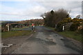
1
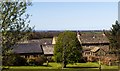
Crosshill Farm
View of Crosshill Farm.
Image: © Peter McDermott
Taken: 18 Apr 2015
0.01 miles

3
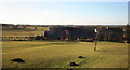
Cross Hill Farm
Moles here are messing up the immaculate lawn.
Image: © Bob Jenkins
Taken: 6 Feb 2009
0.04 miles
4
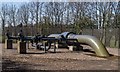
High Pressure Gas Pipe
Valve station for a high pressure gas pipeline.
Image: © Peter McDermott
Taken: 18 Apr 2015
0.18 miles
5

Cattle grid southeast of Crosshill Farm
Image: © Alexander P Kapp
Taken: 18 Aug 2010
0.20 miles
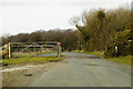
8
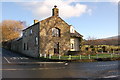
Harris End Fell cross roads
Fine old farmhouse at Harris End Fell cross roads
Image: © Keith Wright
Taken: 4 Jan 2006
0.23 miles
9
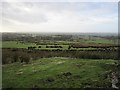
Moor's edge
Dyke between the moorland on Harrisend Fell and improved farmland on the western edge of Bowland.
Image: © Richard Webb
Taken: 23 Dec 2012
0.23 miles
10

Field, Crosshill Four Lane Ends
Oaks are numerous here.
Image: © Richard Webb
Taken: 23 Dec 2012
0.24 miles