IMAGES TAKEN NEAR TO
Oak Hill Drive, PRESTON, PR3 1BZ
Introduction
This page details the photographs taken nearby to Oak Hill Drive, PR3 1BZ by members of the Geograph project.
The Geograph project started in 2005 with the aim of publishing, organising and preserving representative images for every square kilometre of Great Britain, Ireland and the Isle of Man.

There are currently over 7.5m images from over14,400 individuals and you can help contribute to the project by visiting https://www.geograph.org.uk
Image Map
Images are licensed for reuse under creativecommons.org/licenses/by-sa/2.0
Notes
- Clicking on the map will re-center to the selected point.
- The higher the marker number, the further away the image location is from the centre of the postcode.
Image Listing (10 Images Found)
Images are licensed for reuse under creativecommons.org/licenses/by-sa/2.0
Image
Details
Distance
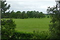
1
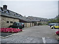
Garstang Country Hotel and Golf Club
Image: © Alexander P Kapp
Taken: 10 Oct 2008
0.09 miles
2
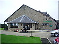
The Bradbeer, Garstang Country Hotel and Golf Club
The bar was named after Richard Bradbeer who designed the golf course
Image: © Alexander P Kapp
Taken: 10 Oct 2008
0.10 miles
3
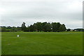
The 1st tee and the 18th green
At the Best Western Garstang Country Hotel and Golf Centre
Image: © Graham Hogg
Taken: 18 Jun 2015
0.11 miles
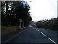
4
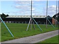
Driving range at Garstang Golf Centre
The wild scatter of balls makes you glad for the netting.
Image: © John M
Taken: 25 Jul 2015
0.11 miles
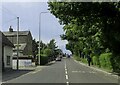
5
The view from room 26
Across the 18th fairway of the golf course at the Best Western Garstang Country Hotel and Golf Centre
Image: © Graham Hogg
Taken: 18 Jun 2015
0.13 miles
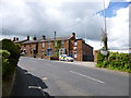
8
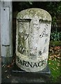
Old Milestone by the B6430, Garstang Road, Bowgreave
Metal plate attached to stone post by the B6430 (was A6), in parish of BARNACRE WITH BONDS (WYRE District), Bowgreave; drive to Cromwell House, 100m South of Police Station, in pavement by streetlamp with back to brick boundary wall by left gate post, between Nos 12 and 14, on West side of road. Garstang flowing text, erected by the Preston & Garstang turnpike trust in the 19th century.
Inscription reads:-
: To / Garstang / ¾ / Mile : : BARNACRE : : To / Preston / 10 / Miles :
Carved benchmark and rivet on top.
Grade II listed.
List Entry Number: 1361909 https://historicengland.org.uk/listing/the-list/list-entry/1361909
Milestone Society National ID: LA_PSGS10.
Image: © A Rosevear
Taken: 7 Sep 2003
0.18 miles
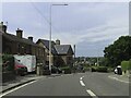
10
Bowgreave, police station
On Garstang Road; the building has a fine plaque with shield and name "Constabulary Station". http://www.lancashire.police.uk/my-area/garstang_caldervale
Image: © Mike Faherty
Taken: 16 May 2012
0.22 miles