IMAGES TAKEN NEAR TO
Woodfold Lane, PRESTON, PR3 1AW
Introduction
This page details the photographs taken nearby to Woodfold Lane, PR3 1AW by members of the Geograph project.
The Geograph project started in 2005 with the aim of publishing, organising and preserving representative images for every square kilometre of Great Britain, Ireland and the Isle of Man.

There are currently over 7.5m images from over14,400 individuals and you can help contribute to the project by visiting https://www.geograph.org.uk
Image Map
Images are licensed for reuse under creativecommons.org/licenses/by-sa/2.0
Notes
- Clicking on the map will re-center to the selected point.
- The higher the marker number, the further away the image location is from the centre of the postcode.
Image Listing (11 Images Found)
Images are licensed for reuse under creativecommons.org/licenses/by-sa/2.0
Image
Details
Distance
1
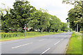
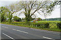
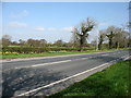
The Old A6 Road
The northern bit of the old road, now by-passed
Image: © Bob Jenkins
Taken: 10 Mar 2009
0.09 miles
2
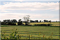
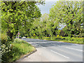
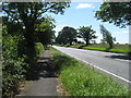
Preston Lancaster Road (A6) near Scorton
Image: © David Dixon
Taken: 24 May 2019
0.10 miles
4
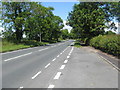
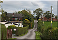
Looking north on the A6
From a layby just to the Cabus.
Image: © James Denham
Taken: 23 Jun 2014
0.12 miles
5
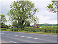
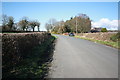
A6 (Preston Lancaster Road) at Woodfold Farm
Image: © David Dixon
Taken: 24 May 2019
0.12 miles
7
A6 road heading south towards Cabus
With Garstang beyond.
Image: © James Denham
Taken: 23 Jun 2014
0.17 miles