IMAGES TAKEN NEAR TO
Copp Lane, PRESTON, PR3 0XQ
Introduction
This page details the photographs taken nearby to Copp Lane, PR3 0XQ by members of the Geograph project.
The Geograph project started in 2005 with the aim of publishing, organising and preserving representative images for every square kilometre of Great Britain, Ireland and the Isle of Man.

There are currently over 7.5m images from over14,400 individuals and you can help contribute to the project by visiting https://www.geograph.org.uk
Image Map (Loading...)


Getting Data...Please wait
Leaflet Map data © OpenStreetMap
Images are licensed for reuse under creativecommons.org/licenses/by-sa/2.0
Notes
- Clicking on the map will re-center to the selected point.
- The higher the marker number, the further away the image location is from the centre of the postcode.
Image Listing (12 Images Found)
Images are licensed for reuse under creativecommons.org/licenses/by-sa/2.0
Image
Details
Distance
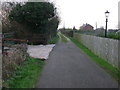
1
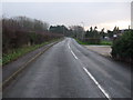
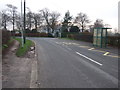
Copp Lane
Heading south west towards Elswick.
Image: © JThomas
Taken: 29 Nov 2014
0.03 miles
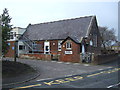
6
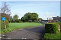
No entry this way
You need to go to the other side of the building to get into this car park.
Image: © Malcolm Neal
Taken: 30 Sep 2019
0.18 miles
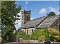
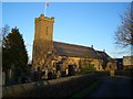
8
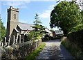
St. Anne's, Copp
Church of England parish church in a small Lancashire village.
Image: © philandju
Taken: 13 Aug 2015
0.19 miles