IMAGES TAKEN NEAR TO
Pinfold Lane, PRESTON, PR3 0TX
Introduction
This page details the photographs taken nearby to Pinfold Lane, PR3 0TX by members of the Geograph project.
The Geograph project started in 2005 with the aim of publishing, organising and preserving representative images for every square kilometre of Great Britain, Ireland and the Isle of Man.

There are currently over 7.5m images from over14,400 individuals and you can help contribute to the project by visiting https://www.geograph.org.uk
Image Map (Loading...)


Getting Data...Please wait
Leaflet Map data © OpenStreetMap
Images are licensed for reuse under creativecommons.org/licenses/by-sa/2.0
Notes
- Clicking on the map will re-center to the selected point.
- The higher the marker number, the further away the image location is from the centre of the postcode.
Image Listing (6 Images Found)
Images are licensed for reuse under creativecommons.org/licenses/by-sa/2.0
Image
Details
Distance
1
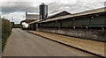
Stanley Farm
Stanley Farm on Pinfold Lane.
Image: © Peter McDermott
Taken: 8 Oct 2016
0.11 miles
2

Small Bridge Near Stanley Farm
The drain here was very smelly and the water grey.
Image: © Bob Jenkins
Taken: 17 Mar 2010
0.20 miles
3
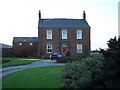
Stanley Farm Sowerby
Large farm once famous for Shire Horses.
Image: © Keith Wright
Taken: 29 Jul 2004
0.21 miles
4
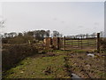
Substantial Stiles
This pair of stiles across the farm track to New House Farm have been constructed from reclaimed bricks.
Image: © Bob Jenkins
Taken: 17 Mar 2010
0.24 miles
6
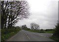
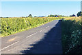
Junction of St Michaels Road and Sowerby Road
Image: © Peter Bond
Taken: 16 Apr 2011
0.25 miles