IMAGES TAKEN NEAR TO
St. Michaels Road, PRESTON, PR3 0RY
Introduction
This page details the photographs taken nearby to St. Michaels Road, PR3 0RY by members of the Geograph project.
The Geograph project started in 2005 with the aim of publishing, organising and preserving representative images for every square kilometre of Great Britain, Ireland and the Isle of Man.

There are currently over 7.5m images from over14,400 individuals and you can help contribute to the project by visiting https://www.geograph.org.uk
Image Map
Images are licensed for reuse under creativecommons.org/licenses/by-sa/2.0
Notes
- Clicking on the map will re-center to the selected point.
- The higher the marker number, the further away the image location is from the centre of the postcode.
Image Listing (17 Images Found)
Images are licensed for reuse under creativecommons.org/licenses/by-sa/2.0
Image
Details
Distance
1
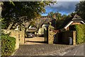
Myerscough
Thatched house in Myerscough.
Image: © Peter McDermott
Taken: 8 Oct 2016
0.08 miles
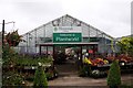
2
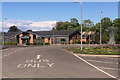
Myerscough College, Veterinary Nursing Centre
Image: © David Dixon
Taken: 11 May 2019
0.09 miles
3
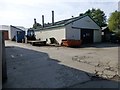
Farm Building At Myerscough College
I walked along the footpath from Bilsborough to Myerscough College.
Image: © Rude Health
Taken: 28 Jul 2014
0.09 miles
5
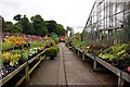
Plant World at Myerscough College
Plants are sold by the students at the horticultural college.
Image: © Steve Daniels
Taken: 8 Jun 2012
0.11 miles
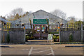
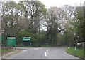
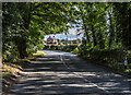
10
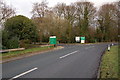
Entrance to Myerscough College
Myerscough is one of the premier agricultural colleges in the country.
Image: © Keith Wright
Taken: 17 Jan 2006
0.13 miles