IMAGES TAKEN NEAR TO
Catterall Lane, PRESTON, PR3 0PA
Introduction
This page details the photographs taken nearby to Catterall Lane, PR3 0PA by members of the Geograph project.
The Geograph project started in 2005 with the aim of publishing, organising and preserving representative images for every square kilometre of Great Britain, Ireland and the Isle of Man.

There are currently over 7.5m images from over14,400 individuals and you can help contribute to the project by visiting https://www.geograph.org.uk
Image Map
Images are licensed for reuse under creativecommons.org/licenses/by-sa/2.0
Notes
- Clicking on the map will re-center to the selected point.
- The higher the marker number, the further away the image location is from the centre of the postcode.
Image Listing (5 Images Found)
Images are licensed for reuse under creativecommons.org/licenses/by-sa/2.0
Image
Details
Distance
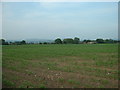
2
Field Entrance
Very muddy, with the River Wyre in the far distance.
Image: © Bob Jenkins
Taken: 6 Mar 2009
0.10 miles
4
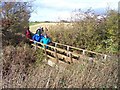
Footbridge near Higher Silcock
On path from Churchtown to Roe Bridge
Image: © Raymond Knapman
Taken: 10 Nov 2008
0.23 miles
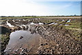
5
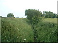
Ditch near Higher Silcock Farm
Looking southwestish, from the footbridge over the ditch.
Image: © David Medcalf
Taken: 1 Jul 2006
0.24 miles